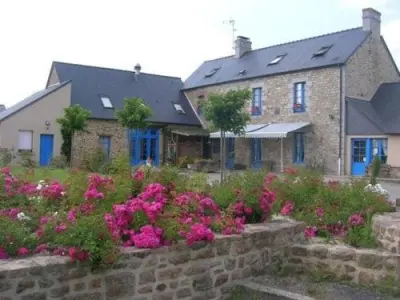
Vendel:
Located 10 km from Fougères and about 35 km from Mont Saint-Michel.
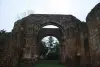
Former capital of the Vendelais time of the Romans. It would have hit the currency.
Its inhabitants: they are called Vendellesiens.
Located 10 km from Fougères and about 35 km from Mont Saint-Michel.
Former capital of the Vendelais time of the Romans. It would have hit the currency.
Its inhabitants: they are called Vendellesiens.
| Municipality | Rives-du-Couesnon |
|---|---|
| Postcode | 35140 |
| Latitude | 48.2894099 (N 48° 17’ 22”) |
| Longitude | -1.3696480 (W 1° 22’ 11”) |
| Altitude | From 42m to 122m |
| Surface area | 48.36 km² |
| Population | 2959 inhabitants |
| Density | 61 inhabitants/km² |
| Prefecture | Rennes (37 km, 32 min) |
| Insee code | 35282 |
| Intercommunality | CA Fougères Agglomération |
| Department | Ille-et-Vilaine |
| Region | Brittany |
| Saint-Aubin-du-Cormier | 4.6 km (6 min) |
|---|---|
| Mézières-sur-Couesnon | 5.9 km (11 min) |
| La Chapelle-Saint-Aubert | 6.8 km (7 min) |
| Saint-Hilaire-des-Landes | 8.3 km (14 min) |
| Saint-Ouen-des-Alleux | 8.7 km (13 min) |
| Saint-Sauveur-des-Landes | 9 km (11 min) |
| Romagné | 9.4 km (9 min) |
| Mecé | 9.7 km (15 min) |
| Gosné | 10.1 km (13 min) |
| Combourtillé | 10.7 km (15 min) |
| Le Tiercent | 11.5 km (17 min) |
| Saint-Christophe-de-Valains | 11.7 km (17 min) |
| Billé | 11.7 km (15 min) |
At the beginning of the 2000s, Merovingian sarcophagi were discovered on the Place du Calvaire.
Its territory is crossed by a Roman road: "Charles Road".
| Monuments |
|---|
| Last name | Activity type | Rate | City |
|---|---|---|---|
 | Arts and Crafts | Free | Dol-de-Bretagne (41 km) |
 | Sports sensations | 100 € | Le Val-Saint-Père (41 km) |
 | Sports sensations | 140 € | Le Val-Saint-Père (41 km) |
| Last name | Outing type | Difficulty | Duration | Departure municipality |
|---|---|---|---|---|
 | Hike | Intermediate | 2:00 | Ercé-près-Liffré (11.5 km) |
 | Hike | Intermediate | 2:10 | La Bouëxière (12.6 km) |
 | Hike | Easy | 2:00 | Liffré (16.3 km) |
 | Hike | Intermediate | 2:00 | Saint-Sulpice-la-Forêt (17.5 km) |
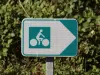 | All-terrain bike itinerary | Athletic | 2:40 | Feins (21 km) |