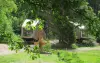
- The Miraumont waterfall.
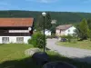
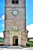
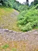
- The Saint Mont, vestiges of a convent.
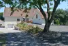
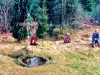
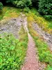
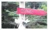
- The Bridge of the Fairies.
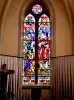
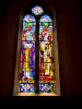
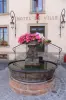
- The chapel (closed) and the fountain Sainte-Sabine.


Favourite


| Municipality | Saint-Étienne-lès-Remiremont |
|---|---|
| Postcode | 88200 |
| Tourism label | ") |
| Latitude | 48.0198520 (N 48° 1’ 11”) |
| Longitude | 6.6106390 (E 6° 36’ 38”) |
| Altitude | From 370m to 819m |
| Surface area | 33.81 km² |
| Population | 3903 inhabitants |
| Density | 115 inhabitants/km² |
| Prefecture | Epinal (30 km, 26 min) |
| Insee code | 88415 |
| Intercommunality | CC de la Porte des Vosges Méridionales |
| Department | Vosges |
| Territory | Lorraine |
| Region | Great East |
| Remiremont | 1.9 km (6 min) |
|---|---|
| Dommartin-lès-Remiremont | 5.5 km (11 min) |
| Saint-Nabord | 5.7 km (10 min) |
| Vecoux | 6.4 km (9 min) |
| Le Syndicat | 6.9 km (8 min) |
| Saint-Amé | 7 km (8 min) |
| Cleurie | 10.1 km (13 min) |
| Éloyes | 10.4 km (14 min) |
| Vagney | 10.7 km (13 min) |
| Raon-aux-Bois | 11.7 km (19 min) |
| La Forge | 12.9 km (13 min) |
| Sapois | 13.2 km (14 min) |
| Rupt-sur-Moselle | 13.4 km (13 min) |
| Jarménil | 14 km (15 min) |
| Gerbamont | 14 km (18 min) |
| Natural sites |
|---|


| Last name | Activity type | Rate | City |
|---|---|---|---|
 | Arts and Crafts | 12 € | Basse-sur-le-Rupt (11.1 km) |
 | Culture and education | 11 € | Le Thillot (19.6 km) |
 | Culture and education | 12 € | Laveline-devant-Bruyères (21 km) |
 | Entertainment | Free | Xonrupt-Longemer (24 km) |
 | Culture and education | 6 € to 8 € | Labaroche (44 km) |
| Last name | Outing type | Difficulty | Duration | Departure municipality |
|---|---|---|---|---|
 | Cycling itinerary | Easy | 3:00 | Vagney (8 km) |
 | Village visit | Easy | 4:00 | Le Tholy (12.1 km) |
 | Hike | Easy | 50 min | Docelles (13.9 km) |
 | Hike | Easy | 2:00 | Liézey (16.3 km) |
 | Snowshoe hike | Easy | 2:30 | Cornimont (18.1 km) |