Saint-Étienne-du-Valdonnez is a commune in the Lozère department, in the Occitanie region, 12 km south-east of Mende.
Ranging from 754 to 1557 m in altitude, its vast mid-mountain territory is notably crossed from north-west to south-east by the Cours du Bramont and is located on the foothills of Mont Lozère, at the is.
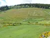
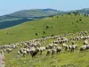
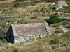
At the crossroads of the Lot and Tarn valleys but also of the Causses des Cévennes in the south, rich in natural sites protected for their biodiversity, the locality made up of a village and numerous hamlets has green landscapes. Its lands are covered with forests (44% of the municipal area), shrubby vegetation (25%) and meadows (22%).
As evidenced by the megaliths, Saint-Étienne-du-Valdonnez has been occupied by man since the Neolithic period. Later, during the Middle Ages, the main town was fortified and a feudal castle erected on the Col de Montmirat, but there are no more testimonies in terms of heritage. On the other hand, there remain vestiges of the galena mines exploited from the 15th century... middle of the 19th century) highlights its natural and landscape riches. Its heritage and its exceptional environment are popular with lovers of green tourism and hiking…
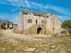
It is in the hamlet of La Fage, a few kilometers south-east of the town of Saint-Étienne, that the most remarkable heritage complex of the town is undoubtedly located: it is a bell tower of torments, a bread oven, a stoup cross, a watering fountain and a "work" to shoe oxen. In the region, these bell towers were established when there was no church as such. Of the "bell tower-wall" type, with a single bay with a semicircular arch, erected on a rectangular base, and surmounted by a cross, their vocation was versatile. They sounded the death knell or the Angelus, warned the population in the event of thunderstorms, signaled the places during heavy mist or fog and also served as a call for school. The tormented bell tower of La Fage dates from the 19th century.
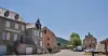
Also in terms of heritage, it is worth mentioning the parish church of Saint-Étienne, which was rebuilt from the end of the 19th century to replace a medieval chapel then dilapidated. The nave dates from 1890, while the choir, the chapels and the bell tower were erected between 1903 and 1909 on the site of the old cemetery. The building was restored in the 1990s and its furniture renewed (high altar, tabernacle, set of windows). Several preserved elements are classified as objects such as a statue of the Virgin and Child.
In the hamlet of Laubies Basses, in the south-east of the territory, the Sainte-Croix church dates from 1850 and its bell tower was rebuilt in 1899. It houses a reliquary of the "true cross", furniture beautifully crafted (altars, pulpit, 19th century confessionals), a singular Stations of the Cross in plaster as well as a number of statues (Saint Anthony of Padua, Saint Vianney Curé of Ars, Saint Joseph and the Child, Saint Thérèse of Lisieux, Saint Privat, Virgin of Lourdes…).
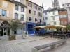
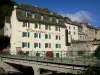
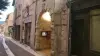
Finally, in addition to wayside crosses or fountains throughout the town, in the town in particular, old houses and shops of character are to be observed.
On the leisure side, cultural events (meetings, exhibitions, shows) are offered regularly at the village hall or the Saint-Etienne library: information on +33 4 66 48 01 66.
In addition to a playground for children, for athletes, a pump truck track and a tennis court are accessible: contact +33 4 66 48 01 66. In addition, the ground of the local motocross club is famous: join +33 6 36 98 28 05 to to check the terms of use.
A nice walk then leads to the lake (or pond) of Barrandon. On the foothills of Mont Lozère, at an altitude of 1375 m, 7 hectares wide, it is partly dedicated to fishermen (presence of trout). Inquire on +33 4 66 65 60 00.
The spectacular Bramont gorges, the foothills of the Cévennes peaks or Mont Lozère, the wooded hillsides of the valleys, and the arid causses are finally and above all potential goals for hikes dotted with viewpoints and protected areas (fauna, flora).
The town is also crossed by several marked routes: the GR 43 (which connects Sainte-Eulalie and the Col des Faïsses), the GR 44 (which connects Les Vans to Champerboux by crossing the departments of Ardèche, Gard and Lozère), the GR 68 (a 118 km loop around Mont Lozère) and finally the GR 670 (which leads from Nasbinals to Avignon via Aubrac, Lozère and the Cévennes). Whether taken for a few kilometers or longer sections, these routes sometimes include difficulties. Be careful also in summer not to forget your water bottles and water bottles! For hikes, maps and information on +33 4 66 65 60 00 or +33 4 66 45 01 14.