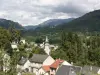
Saint-Cirgues-de-Jordanne is a town in Cantal, in the Auvergne-Rhône-Alpes region, 17 km north-east of Aurillac.
Its territory of 16 km² extends from 733 to 1520 m above sea level, dominated in particular to the north by the Puy de Bassierou which rises to 1444 m.
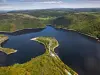
It is crossed by the course of the Jordanne, which originates at the foot of Puy Mary, about twenty kilometers to the northeast and which flows into the Cère at Aurillac, to the southwest of the locality. At the level of the town and its neighbor of Lascelle, to the south, the river flows in gorges cut into the volcanic subsoil, deep up to 60 m! They constitute one of the points of tourist attraction of this locality which has remained very rural. The nature of its landscapes bears witness to this: the land is made up of 35% meadows, 31% forests, more than 30% agricultural environments…
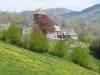
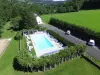
In the southwest of the Cantal mountains, agricultural activity is is now supplemented by tourism, between the chestnut groves of the country of Aurillac and the high reliefs of the Massif Central. An exceptional environment which obviously appeals to hikers... If Saint-Cirgues-de-Jordanne has only nearly 150 inhabitants, in season, we will be pleased to take advantage of the many trails that dot the village and its surroundings.
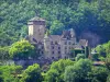
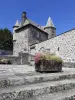
In terms of heritage, the church of Saint-Cyr and Sainte-Juliette is the jewel of the small town. Its oldest parts date from the 12th century. This is the case of the choir, of the apse in cul-de-four but also of the very beautiful "comb bell tower", that is to say in the form of a raised wall pierced with large windows for the bells. These elements are typical of the Romanesque style in Cantal. In the 15th century, the church which served a small priory attached to the Saint-Gérauld d'Aurillac abbey was remodeled (nave, chapels). In addition, the sacristy and the covered porch date from 1667, as well as the stone cross in the square. The nave is decorated with paintings (at the level of the vault and the walls) of the 19th century. Lastly, the building protected as historical monuments houses classified objects and furniture (chalices, crosses, altar, paten).
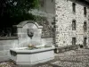
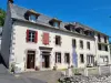
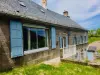
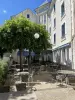
In the village, there are also some typical old houses (in volcanic stone) and traditional agricultural complexes dedicated to livestock (the land of Salers is close...).
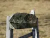
Then it is time for "nature" leisure activities. A "discovery trail" of the Gorges de la Jordanne has been created. It follows the course of the river between the Méjanet bridge, below Saint-Julien-de-Jordanne, to the north of the town, and the Gétine bridge, to the south, on the border between Saint-Cirgues-de-Jordanne and Lascelles. In this sector, the river winds for more than 3 km in the hollow of gorges with a depth varying from 20 to 60 m. The landscape is obviously very different from that of the surrounding meadows and peaks. The already existing banks and fishermen's paths have been supplemented by stone and wood paths and structures. We admire this exceptional natural setting, waterfalls, and a unique environment in terms of flora and fauna. Bollards set up on the trail allow trees or animal footprints to be identified.
For thrill seekers, via the MurMur et Nature organization, monkey bridges and zip lines to cross the river, a via ferrata and a center dedicated to canyoning are also available.
The trail is open from June to September (bring suitable shoes) and the rest of the year by reservation for groups. Price: 1.50 and 4 euros. Information on +33 4 71 47 93 95. For the MurMur and Nature center, information on +33 6 09 35 21 67.
For hiking, the potential of paths crossing the town is very wide. Certain routes reaching the summits and puys overlooking Saint-Cirgues are obviously reserved for accomplished walkers. Routes also allow you to reach the chestnut groves to the south. Maps and information on +33 4 71 48 46 58.
As for mountain biking enthusiasts, they can take routes traced along the Jordanne valley and coordinated by the Mandaille mountain bike base: contact +33 4 71 20 31 61.
Finally, we will not forget to get information from the departmental office of the Regional Natural Park of the Volcanoes of Auvergne, of which the municipality is a member, and which regularly offers themed hikes, exhibitions and various activities: join the +33 4 71 20 09 47.