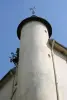
- St. Lawrence Church.
- Spinning Fonty.
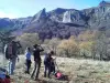
- Geocaching Tour Cycling terra Aventura "Fonty file through fields."
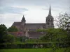
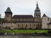


Favourite


| Municipality | Rougnat |
|---|---|
| Postcode | 23700 |
| Latitude | 46.0539840 (N 46° 3’ 14”) |
| Longitude | 2.4996999 (E 2° 29’ 59”) |
| Altitude | From 430m to 669m |
| Surface area | 41.01 km² |
| Population | 489 inhabitants |
| Density | 11 inhabitants/km² |
| Prefecture | Guéret (66 km, 58 min) |
| Insee code | 23164 |
| Intercommunality | CC Marche et Combraille en Aquitaine |
| Department | Creuse |
| Territories | Limousin, Massif Central |
| Region | New-Aquitaine |
| Auzances | 3.8 km (8 min) |
|---|---|
| Fontanières | 6.1 km (7 min) |
| Reterre | 8.4 km (9 min) |
| Charron | 8.6 km (17 min) |
| Le Compas | 9.2 km (14 min) |
| Les Mars | 10.6 km (17 min) |
| Bussière-Nouvelle | 10.6 km (15 min) |
| Arfeuille-Châtain | 11.4 km (16 min) |
| Brousse | 11.7 km (17 min) |
| Châtelard | 12.2 km (19 min) |
| Saint-Julien-la-Genête | 12.3 km (14 min) |
| Dontreix | 12.5 km (17 min) |
| Sermur | 12.9 km (20 min) |
| Saint-Maurice-près-Pionsat | 14 km (24 min) |
| Last name | Activity type | Rate | City |
|---|---|---|---|
 | Nature and the great outdoors | 7 € | Chapdes-Beaufort (33 km) |
 | Nature and the great outdoors | 140 € to 240 € | Volvic (46 km) |
| Last name | Outing type | Difficulty | Duration | Departure municipality |
|---|---|---|---|---|
 | Hike | Easy | 2:00 | Évaux-les-Bains (13.5 km) |
 | Hike | Intermediate | 2:20 | Évaux-les-Bains (13.5 km) |
 | Car itinerary | Easy | 1:35 | Évaux-les-Bains (13.7 km) |
 | Hike | Easy | 2:00 | Chambon-sur-Voueize (16 km) |
 | Cycling itinerary | Intermediate | 4:35 | Miremont (24 km) |