Liven up your holidays!

Résigny

Tourism, holidays & weekends guide in the Aisne

This town is situated on the border of the Ardennes.

The origin of Résigny goes way back. This land is referred to as: Lisiniacus in a charter of the year 865.

Résigny is surrounded by woods. Some loggers, carpenters, charcoal burners lived there. These men found themselves around the hearth together. The word "Ignis" which means the lamp "usus-Ignis" the place of fire. This place where we cooked over time would become "Reses-Ignis" where stabilized the household. Found to Ressignis 1276.

Résigny counted up to 900 people in 1836. The town has five hamlets: the board Serre, Gratreux, Tran, gills and the station area.

Why Serre board: it is said that once, a thick board allowed people to cross the river Serre.

The hamlet of Tran once formed a city and maybe even a city.

Geographical information

MunicipalityRésigny
Postcode02360
Latitude49.7369510 (N 49° 44’ 13”)
Longitude4.2067290 (E 4° 12’ 24”)
AltitudeFrom 157m to 244m
Surface area7.83 km²
Population169 inhabitants
Density21 inhabitants/km²
PrefectureLaon (52 km, 1:04)
Insee code02642
IntercommunalityCC des Portes de la Thiérache
DepartmentAisne
TerritoryPicardy
RegionHauts-de-France

Nearest cities & towns

Grandrieux1.8 km (4 min)
Mainbresson2.8 km (4 min)
Les Autels4 km (8 min)
Parfondeval4.1 km (9 min)
Brunehamel4.9 km (7 min)
Rouvroy-sur-Serre5.1 km (9 min)
Blanchefosse-et-Bay5.6 km (9 min)
Rozoy-sur-Serre7.5 km (11 min)
Mont-Saint-Jean7.7 km (11 min)
Archon7.8 km (15 min)
Rocquigny7.8 km (12 min)
Rubigny8.1 km (15 min)
Iviers8.1 km (11 min)
Dohis8.3 km (13 min)

Things to see and do

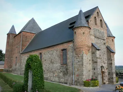
The Church of St. Nicolas built of wood and brick.

Weather

Friday 19 april
Min. 6°C - Max. 10°C
Day
Night
Saturday 20 april
Min. 3°C - Max. 10°C
Day
Night
Sunday 21 april
Min. 3°C - Max. 12°C
Day
Night

Visits, leisure and activities nearby

Leisure activities

Last nameActivity typeRateCity
Evening at Dommery astronomic observatory
Culture and education10 € to 80 € Dommery (20 km)

Outings

Last nameOuting typeDifficultyDurationDeparture municipality
Sorcy Wood
Mountain bike itineraryEasy1:30Écordal (36 km)
Circuit "La Meuse des Deux Villes"
HikeIntermediate2:40Charleville-Mézières (37 km)
The Castrice Walk
HikeEasy2:00Charleville-Mézières (37 km)
Pâquis Loop
HikeEasy2:30Vouziers (52 km)
Between forest and heritage
All-terrain bike itineraryIntermediate4:35Sedan (52 km)

Restaurants

Bed & breakfasts

Vacation rentals

Campsites

Hotels

Your holidays
A hotel
A vacation rental
A bed & breakfast
A campsite
A leisure activity
A restaurant
A rental car
A plane ticket
By continuing to browse our site, you are agreeing to the use of cookies to improve your experience and make targeted offers.
Find out more and make settings
Your account