- Beaches Plestin-les-Greves.
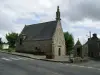
- Cliffs and churchyard Trédrez.
- Church and stairs Brélévenez in Lannion.
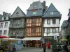
- Côte de Granit Rose: Perros-Guirec, Trégastel, Trébeurden.
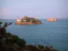
- Great Site Naturel Ploumanac'h.
- Radome Pleumeur-Bodou.
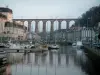
- Morlaix Viaduct.


Favourite


| Municipality | Plouégat-Guérand |
|---|---|
| Postcode | 29620 |
| Latitude | 48.6210639 (N 48° 37’ 16”) |
| Longitude | -3.6754570 (W 3° 40’ 32”) |
| Altitude | From 2m to 151m |
| Surface area | 17.29 km² |
| Population | 1084 inhabitants |
| Density | 62 inhabitants/km² |
| Prefecture | Quimper (99 km, 1:28) |
| Insee code | 29182 |
| Intercommunality | CA Morlaix Communauté |
| Department | Finistère |
| Region | Brittany |
| Lanmeur | 5.1 km (9 min) |
|---|---|
| Plestin-les-Grèves | 6 km (8 min) |
| Trémel | 6.4 km (14 min) |
| Guimaëc | 7.8 km (10 min) |
| Plouigneau | 8.6 km (10 min) |
| Locquirec | 10.3 km (16 min) |
| Tréduder | 11.6 km (16 min) |
| Garlan | 11.7 km (16 min) |
| Saint-Michel-en-Grève | 12.9 km (15 min) |
| Saint-Jean-du-Doigt | 12.9 km (17 min) |
| Plougasnou | 13.5 km (17 min) |
| Plouzélambre | 14 km (20 min) |
| Plougonven | 14.3 km (20 min) |
| Last name | Outing type | Difficulty | Duration | Departure municipality |
|---|---|---|---|---|
 | Hike | Easy | 1:50 | Lanvellec (10.1 km) |
 | Hike | Easy | 2:15 | Plounérin (11.6 km) |
 | Hike | Easy | 1:25 | Plouaret (14.9 km) |
 | Hike | Easy | 55 min | Plougras (17.1 km) |
 | Hike | Intermediate | 2:35 | Loguivy-Plougras (20 km) |