


Favourite
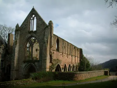
Beauport Abbey


| Municipality | Pabu |
|---|---|
| Postcode | 22200 |
| Latitude | 48.5866410 (N 48° 35’ 12”) |
| Longitude | -3.1365240 (W 3° 8’ 11”) |
| Altitude | From 50m to 137m |
| Surface area | 7.83 km² |
| Population | 2861 inhabitants |
| Density | 365 inhabitants/km² |
| Prefecture | Saint-Brieuc (38 km, 33 min) |
| Insee code | 22161 |
| Intercommunality | CA Guingamp-Paimpol Agglomération de l'Armor à l'Argoat |
| Department | Côtes-d'Armor |
| Region | Brittany |
| Guingamp | 4.2 km (9 min) |
|---|---|
| Squiffiec | 5.5 km (9 min) |
| Trégonneau | 5.6 km (9 min) |
| Saint-Agathon | 5.8 km (9 min) |
| Pommerit-le-Vicomte | 5.9 km (8 min) |
| Grâces | 6.2 km (12 min) |
| Plouisy | 6.4 km (12 min) |
| Ploumagoar | 7.5 km (11 min) |
| Le Merzer | 8.9 km (10 min) |
| Saint-Clet | 9.7 km (10 min) |
| Kermoroc'h | 10.1 km (14 min) |
| Coadout | 10.5 km (15 min) |
| Saint-Gilles-les-Bois | 10.6 km (12 min) |
| Performance halls |
|---|

| Last name | Outing type | Difficulty | Duration | Departure municipality |
|---|---|---|---|---|
 | Mountain bike itinerary | Easy | 30 min | Plouisy (4.7 km) |
| Hike | Intermediate | 2:30 | Plouha (18.4 km) |
| Hike | Intermediate | 1:30 | Plourivo (18.9 km) |
 | Hike | Easy | 2:00 | Paimpol (22 km) |
 | Hike | Easy | 1:25 | Plouaret (25 km) |


