Murbach is a town in Haut-Rhin, in the Grand Est region, 29 km northwest of Mulhouse.
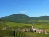
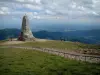
Its territory of 6.6 km² ranges from 396 to 1420 m above sea level, dominated to the south-west by the summit of the Grand Ballon, also known as Ballon de Guebwiller, the highest Vosges massif of the Alsatian peaks and which culminates at 1424 m.
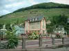
The village itself developed in a deep valley crossed by the Murbach stream.
The history of the locality, covered with forests (83% of its area), is closely linked to that of the Benedictine abbey which was founded there by Saint Pirmin, a Visigoth monk, in 728. number of Irish monks and had its heyday in the Middle Ages, its possessions extending over a vast territory. While it is already weakened, the Revolution was fatal to the monastery.
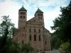
Although only vestiges of the abbey church remain, the town, which today has around 150 inhabitants, has preserved other elements of its heritage.
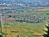
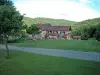
In a very green mid-mountain environment, it highlights its cultural dynamism and exceptional potential for hiking enthusiasts…
A visit is a must during a stay in the south of Alsace.
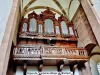
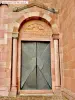
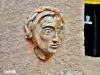
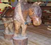
It was therefore the Benedictine abbey founded in the 8th century in a natural setting that was quite hostile at the time, which marked the birth of the locality. With the support of Count Eberhard (known as Eguisheim), the first monks to come for many from Ireland cleared the territory and at the turn of the 10th century, the possessions of the abbey extended on both sides of the Rhine., and even to a part of present-day Switzerland. Ravaged by Hungarian troops at the dawn of the second millennium, Murbach is recovering and resuming its growth. Its prestige is such that its abbot is now prince of the Holy Empire and only depends on the pope on the religious level. Spiritual and cultural capital (its library is famous throughout Europe), the abbey began to decline when the system of commendation was introduced (its abbots could now be lay people). However, having become a principality, it was attached to France and even the Thirty Years War did not alter its prestige and its dynamism. While a new restoration campaign began in the 18th century, and the church had to be rebuilt in a Baroque style, the site stalled and in 1759, the monks left Murbach to settle in Guebwiller. During the Revolution, the buildings were ransacked, and today only the choir and the transept of the church remain, entirely built in pink and white sandstone in a Romanesque style (12th century). The nave which was to be rebuilt never was… The flat and slender apse is surprising for the time. There are two large pink sandstone towers surmounting the transept. The elegant facade has rich decorations, with two rows of arcaded windows, a gallery with columns, sculptures representing faces and animals. The "east" portal is a masterpiece of sculpture... Inside, in addition to the more recent stained glass windows, the recumbent statue of Count Eberhard in painted sandstone has been preserved. An altarpiece, statues and an organ of spectacular dimensions attest to the richness of the site.
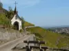
To be seen next, the Notre-Dame de Lorette chapel built in a Baroque style in 1693, on a wooded height dominating the old abbey (hence an unrivaled view…). Housing relics, adorned with a superb sundial made in the 18th century on its rear wall, the chapel has been restored several times (the last time in 1998) and its frescoed interior (including a celestial vault) is a model of the kind…
On the path leading to the chapel, you should also admire the Stations of the Cross laid out in 1873 by the priest Jean-Thébaut Mellecker. The first eleven stations are simple crosses bearing quotations from the Gospels. The twelfth consists of a cross at the foot of which we observe Mary Magdalene, the thirteenth station represents the deposition of the cross and the last evokes the burial of Christ in the form of a grotto leaning against the mountain.
Finally, the ruins of Hohenrupf castle (13th century) which protected the monastery and still served as an observatory during the First World War and a 19th century Celtic cross in the cemetery, probably referring to the Irish monks of the early days of the abbey, are still to be mentioned in this overview of the heritage of the town with a rich past.
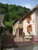
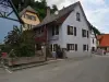
All that remains is to take advantage of the potential in terms of hiking or mountain biking from the village, which now includes a few farms and typical mountain dwellings.
Several marked trails are dedicated to walkers, leading for example to the ruins of the medieval castle or the pass and the summit of Judenhut (to the south-west): note that some paths can be covered on snowshoes in winter... other routes are accessible to mountain bikers, and include some difficulties if necessary. But the beauty of the landscapes (forests, waterfalls, pink sandstone) and the panoramas are well worth the effort! Maps and information on +33 3 89 76 10 63.
It is also useful to find out about workshops, conferences or other activities offered by the Ballons des Vosges Regional Natural Park of which the town is a member: contact +33 3 89 77 90 20.
On the last weekend of May, in even years, "Art and stroll" offers artistic exhibitions in different points and dwellings of the village to discover during a walk...
The first Saturday of July, festival "La tête dans the clouds" with fun activities and a concert.