Liven up your holidays!

Montjoie-en-Couserans

Tourism, holidays & weekends guide in the Ariège

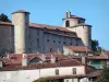
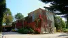
Fortified village and its church of the thirteenth century fortified itself.

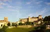
Montjoie-en-Couserans could be derived from Mons Jovis, " Mount of Jupiter." The Gauls worshiped their ancestors and if he was a king or hero, he became a demigod and his descendants made ​​him a cult. For his powers act better, it was useful to have his tomb was venerated, and where the Celts were spending the night to collect his oracles. They associèrent the worship of a god to worship of an ancient tumulus, and this is what must take place Lendit. This divine ancestor is unknown but it may be noted that it is possible that this god was assimilated to Jupiter because the place was called Mons Jovis, " Mount of Jupiter."

Geographical information

MunicipalityMontjoie-en-Couserans
Postcode09200
Latitude43.0016320 (N 43° 0’ 6”)
Longitude1.1596800 (E 1° 9’ 35”)
AltitudeFrom 393m to 677m
Surface area29.63 km²
Population1031 inhabitants
Density34 inhabitants/km²
PrefectureFoix (43 km, 44 min)
Insee code09209
IntercommunalityCC Couserans-Pyrénées
DepartmentAriège
TerritoriesMidi-Pyrénées, Pyrenees
RegionOccitanie

Nearest cities & towns

Saint-Lizier2.1 km (5 min)
Saint-Girons3.3 km (7 min)
Lorp-Sentaraille4.3 km (10 min)
Gajan4.8 km (10 min)
Montesquieu-Avantès5.5 km (10 min)
Eycheil5.7 km (11 min)
Taurignan-Vieux5.8 km (10 min)
Montgauch7.4 km (16 min)
Caumont7.6 km (13 min)
Encourtiech7.6 km (13 min)
Montégut-en-Couserans7.9 km (16 min)
Lacourt8 km (12 min)
Taurignan-Castet8.1 km (14 min)
Moulis8.2 km (12 min)

Photos

Church tower of Montjoie
See photo

Weather

Thursday 25 april
Min. 5°C - Max. 13°C
Day
Night
Friday 26 april
Min. 5°C - Max. 16°C
Day
Night
Saturday 27 april
Min. 8°C - Max. 20°C
Day
Night

Visits, leisure and activities nearby

Leisure activities

Last nameActivity typeRateCity
Carriage ride with cart horses
Nature and the great outdoors75 € to 576 € Camarade (13.8 km)

Outings

Last nameOuting typeDifficultyDurationDeparture municipality
Gr 78
Village visitEasy4:00Galey (21 km)
The Greenway
HikeEasy4:00La Bastide-de-Sérou (22 km)
Along the waterway
Village visitIntermediate2:00Carbonne (33 km)
Tour of the Peak Pinçon
HikeIntermediate3:00Bize (56 km)
Lombez, audio tour of the historic heart
HikeEasy35 minLombez (56 km)

Restaurants

Bed & breakfasts

Vacation rentals

Campsites

Hotels

Your holidays
A hotel
A vacation rental
A bed & breakfast
A campsite
A leisure activity
A restaurant
A rental car
A plane ticket
By continuing to browse our site, you are agreeing to the use of cookies to improve your experience and make targeted offers.
Find out more and make settings
Your account