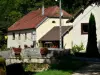
The vertical access to the Orcières cave, located in the wood, to the south-east of the village, can only be done with the help of a ladder.

Favourite


| Municipality | Montivernage |
|---|---|
| Postcode | 25110 |
| Latitude | 47.3172190 (N 47° 19’ 2”) |
| Longitude | 6.4261500 (E 6° 25’ 34”) |
| Altitude | From 390m to 541m |
| Surface area | 3.34 km² |
| Population | 27 inhabitants |
| Density | 8 inhabitants/km² |
| Prefecture | Besançon (42 km, 44 min) |
| Insee code | 25401 |
| Intercommunality | CC du Doubs Baumois |
| Department | Doubs |
| Territories | Franche-Comté, Jura mountains |
| Region | Burgundy-Franche-Comté |
| Guillon-les-Bains | 3.2 km (5 min) |
|---|---|
| Lanans | 4.1 km (7 min) |
| Servin | 5.9 km (10 min) |
| Cusance | 5.9 km (9 min) |
| Pont-les-Moulins | 6.3 km (10 min) |
| Vaudrivillers | 6.6 km (8 min) |
| Vellevans | 8.7 km (12 min) |
| Ouvans | 9 km (15 min) |
| Lomont-sur-Crête | 9.5 km (17 min) |
| Passavant | 10.1 km (14 min) |
| Villers-Saint-Martin | 10.8 km (16 min) |
| Adam-lès-Passavant | 11 km (13 min) |
| Randevillers | 11.1 km (13 min) |
| Saint-Juan | 11.8 km (16 min) |
The vertical access to the Orcières cave, located in the wood, to the south-east of the village, can only be done with the help of a ladder.


| Last name | Activity type | Rate | City |
|---|---|---|---|
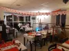
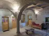
 | Entertainment | 84 € to 110 € | Besançon (32 km) |
| Last name | Outing type | Difficulty | Duration | Departure municipality |
|---|---|---|---|---|
 | Hike | Easy | 1:00 | Pays-de-Clerval (10 km) |
 | Hike | Easy | 6:00 | Devecey (31 km) |
 | Hike | Intermediate | 35 min | Grand-Charmont (37 km) |
 | Hike | Intermediate | 35 min | Hauterive-la-Fresse (39 km) |
 | Hike | Athletic | 5:05 | Fretigney-et-Velloreille (40 km) |