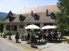
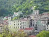
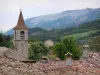
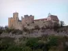
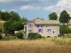
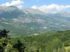
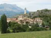
Common Natural Regional Natural Park of Baronnies Provençales, located 3 km from Serres, crossroads between the valleys of Buëch and Rosanais.


Favourite
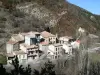


Common Natural Regional Natural Park of Baronnies Provençales, located 3 km from Serres, crossroads between the valleys of Buëch and Rosanais.
| Municipality | Montclus |
|---|---|
| Postcode | 05700 |
| Latitude | 44.4148780 (N 44° 24’ 54”) |
| Longitude | 5.6830600 (E 5° 40’ 59”) |
| Altitude | From 680m to 1546m |
| Surface area | 21.25 km² |
| Population | 54 inhabitants |
| Density | 2 inhabitants/km² |
| Prefecture | Gap (44 km, 44 min) |
| Insee code | 05081 |
| Intercommunality | CC du Sisteronais-Buëch |
| Department | Hautes-Alpes |
| Territories | Alps, Dauphiné |
| Region | Provence-Alps-French Riviera |
| Serres | 3.4 km (5 min) |
|---|---|
| L'Épine | 6.2 km (7 min) |
| Sigottier | 7.4 km (11 min) |
| Méreuil | 8.8 km (14 min) |
| Le Bersac | 9.1 km (12 min) |
| Montrond | 9.3 km (11 min) |
| La Bâtie-Montsaléon | 10.9 km (14 min) |
| Aspremont | 11.3 km (13 min) |
| Chanousse | 11.3 km (27 min) |
| Ribeyret | 11.3 km (12 min) |
| La Piarre | 11.8 km (17 min) |
| Savournon | 12.4 km (16 min) |
| Trescléoux | 13.2 km (21 min) |
| Chabestan | 13.4 km (16 min) |
| Natural sites |
|---|
| Last name | Activity type | Rate | City |
|---|---|---|---|
 | Nature and the great outdoors | 50 € to 375 € | Éourres (23 km) |
 | Arts and Crafts | 30 € | Saint-Vincent-sur-Jabron (27 km) |
 | Local flavours | Free | Noyers-sur-Jabron (29 km) |
 | Local flavours | Free | Sault (40 km) |
 | Well-being | Free | Sault (42 km) |
| Last name | Outing type | Difficulty | Duration | Departure municipality |
|---|---|---|---|---|
 | Hike | Intermediate | 2:15 | La Faurie (17.5 km) |
 | Hike | Easy | 1:00 | Montfroc (29 km) |
 | Hike | Intermediate | 5:00 | La Bâtie-Vieille (41 km) |
 | Hike | Easy | 3:00 | La Bâtie-Vieille (41 km) |
 | Hike | Athletic | 7:00 | Cruis (41 km) |