Town located overlooking the Doubs valley and plateau Maîche. The area lends itself to tourism trips with remarkable views, caves and a farm visit. The "Porte de France" is ready to climb.


Favourite
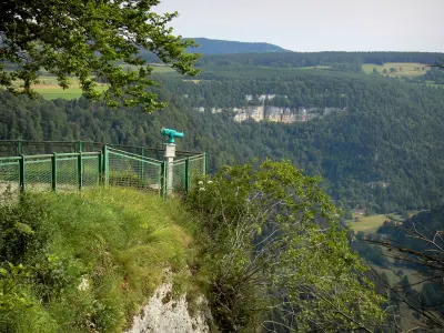
Town located overlooking the Doubs valley and plateau Maîche. The area lends itself to tourism trips with remarkable views, caves and a farm visit. The "Porte de France" is ready to climb.
| Municipality | Montandon |
|---|---|
| Postcode | 25190 |
| Latitude | 47.2971700 (N 47° 17’ 50”) |
| Longitude | 6.8347090 (E 6° 50’ 5”) |
| Altitude | From 520m to 880m |
| Surface area | 12.71 km² |
| Population | 384 inhabitants |
| Density | 30 inhabitants/km² |
| Prefecture | Besançon (103 km, 1:18) |
| Insee code | 25387 |
| Intercommunality | CC du Pays de Maîche |
| Department | Doubs |
| Territories | Franche-Comté, Jura mountains |
| Region | Burgundy-Franche-Comté |
| Les Bréseux | 4.4 km (9 min) |
|---|---|
| Thiébouhans | 5.1 km (9 min) |
| Maîche | 6.4 km (10 min) |
| Trévillers | 6.8 km (11 min) |
| Les Plains-et-Grands-Essarts | 8.8 km (16 min) |
| Fessevillers | 9.3 km (16 min) |
| Mancenans-Lizerne | 9.4 km (15 min) |
| Saint-Hippolyte | 10 km (13 min) |
| Ferrières-le-Lac | 10.1 km (16 min) |
| Cernay-l'Église | 10.2 km (17 min) |
| Les Écorces | 11.2 km (17 min) |
| Belfays | 11.3 km (19 min) |
| Damprichard | 11.9 km (19 min) |
| Courtefontaine | 12.1 km (21 min) |
Hiking.

| Last name | Outing type | Difficulty | Duration | Departure municipality |
|---|---|---|---|---|
 | Hike | Intermediate | 35 min | Grand-Charmont (25 km) |
 | Hike | Easy | 1:00 | Pays-de-Clerval (28 km) |
 | Hike | Intermediate | 35 min | Hauterive-la-Fresse (46 km) |
 | Hike | Intermediate | 1:00 | Burnhaupt-le-Haut (54 km) |
 | Village visit | Easy | 1:00 | Masevaux-Niederbruck (54 km) |


