

Favourite
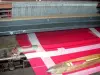
Cholet and its Textile museum
| Municipality | Mazières-en-Mauges |
|---|---|
| Postcode | 49280 |
| Latitude | 47.0461800 (N 47° 2’ 46”) |
| Longitude | -0.8161000 (W 0° 48’ 58”) |
| Altitude | From 88m to 163m |
| Surface area | 8.90 km² |
| Population | 1295 inhabitants |
| Density | 145 inhabitants/km² |
| Prefecture | Angers (68 km, 49 min) |
| Insee code | 49195 |
| Intercommunality | CA Agglomération du Choletais |
| Department | Maine-et-Loire |
| Territories | Anjou, Loire Valley |
| Region | Pays de la Loire |
| Toutlemonde | 4.8 km (6 min) |
|---|---|
| La Tessoualle | 6.3 km (9 min) |
| Cholet | 6.6 km (12 min) |
| Maulévrier | 7.8 km (7 min) |
| Nuaillé | 7.9 km (13 min) |
| Saint-Pierre-des-Échaubrognes | 9.8 km (9 min) |
| Trémentines | 10.4 km (15 min) |
| Yzernay | 11.3 km (12 min) |
| La Séguinière | 12.1 km (15 min) |
| Saint-Christophe-du-Bois | 12.2 km (15 min) |
| Saint-Léger-sous-Cholet | 13.3 km (15 min) |
| Chanteloup-les-Bois | 13.3 km (16 min) |
| Vezins | 14.3 km (17 min) |
| Saint-Laurent-sur-Sèvre | 14.5 km (20 min) |
| Last name | Outing type | Difficulty | Duration | Departure municipality |
|---|---|---|---|---|
 | Hike | Easy | 1:30 | Les Epesses (18.5 km) |
 | Hike | Easy | 2:00 | Beaupréau-en-Mauges (22 km) |
 | Hike | Easy | 2:00 | Montrevault-sur-Èvre (30 km) |
 | All-terrain bike itinerary | Easy | 1:20 | Ingrandes-Le Fresne sur Loire (40 km) |
 | Cycling itinerary | Easy | 2:00 | Saint-Martin-du-Fouilloux (44 km) |