Maureillas-las-Illas is a large town in 4210 hectares, situated at the foot of the Pyrenees, about thirty kilometers from Perpignan and from Vallespir to Albères. It borders with Spain. Its territory is crossed by the river Rome, and from south to north by the river of Las Illas becomes the Maureillas and joins the Tech.
A mention of Maurelianum, founded by the Romans, appears in 1011 and the first known lord of Ramon Maurellar is quoted in 1147. The village is experiencing a confusing time during the thirteenth century during the wars between the kings of Aragon and Mallorca. We know that the place was home to 60 fires in 1378 and the term Maureillas is listed for the first time in the Middle Ages, in 1395. It was during the Middle Ages that the village has really made around the Casteil, which was the residence of the lords of Oms and until the Treaty of the Pyrenees. The attachment of Roussillon to France, in 1659, pushes one based activity, so far, on trade with Catalonia. In the nineteenth century Maureillas began a period of prosperity by engaging in the cork industry, which is now the museum dedicated Cork. The current territory of Maureillas comes from successive annexations: St. Martin Fenollar, attached to the town in 1822 and Las Illas (which had absorbed La Selva in 1823) and Riunoguès joining the entity in 1972.
A common but three villages with Las Illas and Riunoguès each character and wealth of any order: a unique heritage and natural recreation characterize these three villages.
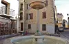
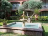
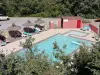
Maureillas, built in the early Middle Ages around a "Cellera" and Saint-Etienne church. One can admire a painting of St. Michael slaying the demon work of Antonin Guerra, objects of worship and stunning views of the Canigou from the narthex. Nearby, the Republic Square, well shaded, is refreshed since the nineteenth century by a fountain (or battery) and offers the services of two restaurants throughout the year. The Prat de la Farga is a recreation area available to residents and visitors, where you can indulge in fishing, walking or riding, practicing fitness trail or bocce. All weekends in summer ball with musical entertainment and refreshments available.
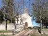
The cork museum represents the glorious past of the village corkmakers and future of this noble material, with surprising and particularly suited to sustainable development properties. Finally, the jewel in Saint Martin de Fenollar, with its pre-Romanesque chapel and its frescoes of the twelfth century, the largest in the South of France, on the surface... and quality!
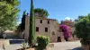
Las Illas, near the border with Catalonia, nestled deep wild valleys, has always been a hotbed of history of Roussillon, Spain and France: Miquelets revolt of the seventeenth century, against king of France ; murderous saga Trabucayres in the nineteenth century; painful episodes of "Retirada" Spanish in 1939 to collar Lli and Manrella: memorials Spanish guerrillas for France and Lluis Companys, the last president of the Generalitat, shot under Franco, in Montjuic in 1940.
Las Illas was a thoroughfare for Evadés of France, and those fleeing oppression in occupied France, from 1940 to 1945: A plaque on the place of the "Llibertat" recalls these "Roads to Freedom".
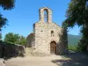
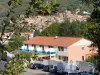
Riunoguès amid Cork Oak Landscapes, ideally placed on the "Green Route" between Maureillas and Le Perthus (Panissars pass) offers a rare pre-Romanesque churches of Roussillon: Saint Michel. A "Aplec" is held at the Saint Michel or the nearest Sunday. The church contains a remarkable altarpiece of the eighteenth century, and a bench of Justice. This is a special monument, visitable on request from the municipality or with the country of art and history.
A rustic inn is open year round. Many excursions are possible as to Las Illas, Maureillas, Les Cluses or nearby Spain.