Mael-Pestivien, land of legends, just "Mael" (Breton saint of Wales), for "penn" (end) and "stivien" (source).
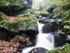
Indeed, this is common on the granite-Duault Quintin, the "water tower" of Brittany.


Mael-Pestivien, land of legends, just "Mael" (Breton saint of Wales), for "penn" (end) and "stivien" (source).
Indeed, this is common on the granite-Duault Quintin, the "water tower" of Brittany.
| Municipality | Maël-Pestivien |
|---|---|
| Postcode | 22160 |
| Latitude | 48.3938310 (N 48° 23’ 38”) |
| Longitude | -3.2973900 (W 3° 17’ 51”) |
| Altitude | From 223m to 302m |
| Surface area | 31.29 km² |
| Population | 359 inhabitants |
| Density | 11 inhabitants/km² |
| Prefecture | Saint-Brieuc (59 km, 50 min) |
| Insee code | 22138 |
| Intercommunality | CA Guingamp-Paimpol Agglomération de l'Armor à l'Argoat |
| Department | Côtes-d'Armor |
| Region | Brittany |
| Bulat-Pestivien | 5.5 km (9 min) |
|---|---|
| Kerien | 6.9 km (9 min) |
| Peumerit-Quintin | 7.3 km (9 min) |
| Saint-Nicodème | 7.4 km (9 min) |
| Saint-Servais | 7.4 km (10 min) |
| Magoar | 9 km (13 min) |
| Lanrivain | 9.3 km (16 min) |
| Trémargat | 10.9 km (20 min) |
| Kergrist-Moëlou | 10.9 km (11 min) |
| Pont-Melvez | 11.5 km (15 min) |
| Locarn | 14.6 km (17 min) |
| Callac | 15 km (19 min) |
| Kerpert | 15.1 km (21 min) |
| Monuments | |
|---|---|
| Natural sites |
| Last name | Outing type | Difficulty | Duration | Departure municipality |
|---|---|---|---|---|
 | Hike | Easy | 1:00 | Locarn (12.4 km) |
 | Village visit | Intermediate | 7:00 | Saint-Nicolas-du-Pélem (13.4 km) |
 | Hike | Easy | 20 min | Loguivy-Plougras (17.4 km) |
 | Hike | Intermediate | 2:35 | Loguivy-Plougras (17.4 km) |
 | Hike | Easy | 55 min | Plougras (21 km) |