Favourite
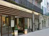
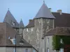
Saint-Pourçain-sur-Sioule
| Municipality | Louchy-Montfand |
|---|---|
| Postcode | 03500 |
| Latitude | 46.3078999 (N 46° 18’ 28”) |
| Longitude | 3.2447160 (E 3° 14’ 41”) |
| Altitude | From 241m to 342m |
| Surface area | 5.33 km² |
| Population | 440 inhabitants |
| Density | 82 inhabitants/km² |
| Prefecture | Moulins (35 km, 34 min) |
| Insee code | 03149 |
| Intercommunality | CC Saint-Pourçain Sioule Limagne |
| Department | Allier |
| Territories | Auvergne, Bourbonnais, Massif Central |
| Region | Auvergne-Rhône-Alps |
| Montord | 2.3 km (4 min) |
|---|---|
| Saulcet | 3.1 km (5 min) |
| Cesset | 3.4 km (6 min) |
| Bransat | 4.2 km (6 min) |
| Saint-Pourçain-sur-Sioule | 4.3 km (7 min) |
| Chareil-Cintrat | 5.1 km (8 min) |
| Verneuil-en-Bourbonnais | 5.6 km (9 min) |
| Fourilles | 9.4 km (14 min) |
| Fleuriel | 9.5 km (15 min) |
| Loriges | 10.7 km (14 min) |
| Contigny | 10.8 km (14 min) |
| Chantelle | 11.6 km (16 min) |
| Laféline | 11.6 km (13 min) |
| Bayet | 12.2 km (16 min) |
| Last name | Activity type | Rate | City |
|---|---|---|---|
 | Nature and the great outdoors | 8 € to 50 € | Noyant-d'Allier (21 km) |
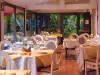
 | Well-being | 65 € to 155 € | Ferrières-sur-Sichon (42 km) |
 | Arts and Crafts | Free | Tresnay (44 km) |
| Last name | Outing type | Difficulty | Duration | Departure municipality |
|---|---|---|---|---|
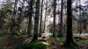
 | Hike | Intermediate | 1:30 | Chantelle (10.5 km) |
 | Hike | Easy | 3:00 | Besson (18.2 km) |
 | Hike | Easy | 1:30 | Valignat (20 km) |
 | Hike | Intermediate | 40 min | Bellerive-sur-Allier (23 km) |
 | Village visit | Easy | 1:00 | Servant (31 km) |