

Favourite
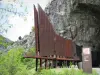
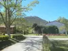
Niaux caves
| Municipality | Lercoul |
|---|---|
| Postcode | 09220 |
| Latitude | 42.7700960 (N 42° 46’ 12”) |
| Longitude | 1.5459740 (E 1° 32’ 46”) |
| Altitude | From 826m to 2876m |
| Surface area | 19.01 km² |
| Population | 15 inhabitants |
| Prefecture | Foix (33 km, 35 min) |
| Insee code | 09162 |
| Intercommunality | CC de la Haute Ariège |
| Department | Ariège |
| Territories | Midi-Pyrénées, Pyrenees |
| Region | Occitanie |
| Siguer | 5.8 km (13 min) |
|---|---|
| Gestiès | 9.4 km (22 min) |
| Capoulet-et-Junac | 10.8 km (21 min) |
| Illier-et-Laramade | 12.6 km (26 min) |
| Miglos | 12.6 km (25 min) |
| Niaux | 12.8 km (21 min) |
| Alliat | 13.3 km (24 min) |
| Val-de-Sos | 14.2 km (23 min) |
| Auzat | 16.1 km (27 min) |
| Orus | 17 km (32 min) |
| Tarascon-sur-Ariège | 17.4 km (30 min) |
| Quié | 17.5 km (30 min) |
| Génat | 17.6 km (35 min) |
| Last name | Activity type | Rate | City |
|---|---|---|---|
 | Nature and the great outdoors | 75 € to 576 € | Camarade (42 km) |
| Last name | Outing type | Difficulty | Duration | Departure municipality |
|---|---|---|---|---|
 | Hike | Easy | 4:00 | La Bastide-de-Sérou (29 km) |
 | Hike | Intermediate | 3:30 | Roquefeuil (37 km) |
 | Hike | Intermediate | 2:00 | Belloc (41 km) |
 | Mountain bike itinerary | Intermediate | 8:00 | Mirepoix (44 km) |
 | Hike | Intermediate | 3:00 | Roquefort-de-Sault (54 km) |