Liven up your holidays!

Le Pescher

Tourism, holidays & weekends guide in the Corrèze

Once a simple trading village of Sérilhac, Le Pescher gained its independence June 25, 1897 at the request of its inhabitants.

Le Pescher, south of Canton Beynat is a place of radiation to sites of famous Lower Corrèze: Beaulieu - Curemonte - Collonges-la-Rouge - Turenne and valleys of the Lot and Dordogne.

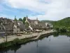
The town settled in the valley of the Sourdoire. The town lies at the crossroads of several major roads, trade routes and tourist destinations: the RD15 linking Brive Beaulieu and Vayrac, which connects the RD10 Tulle Meyssac. The northern Tulle RD940 connects to Beaulieu.

Its population (270 inhabitants) is divided between the village and a dozen villages nestled in green hills alternating fields, meadows, groves, forests and streams that meander more renowned for trout fishing. The heights of the town have exceptional views of the volcanos, the valleys of the Dordogne and the Lot.

Agricultural activity is present and is dedicated to raising "beautiful limousines. Many Peschacois work in nearby towns: Brive (25 km), Tulle (30 km), Biars-sur-Cere (20 km). Commercial firms and craft moved into the area Communal Activities.

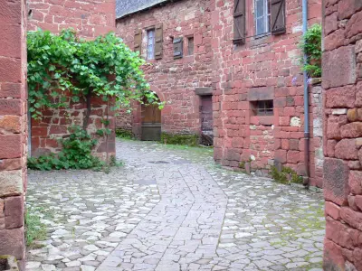
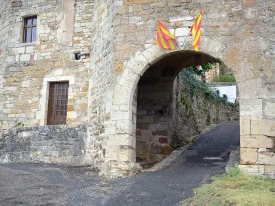
In the town center are the staves of an old castle of the Vicomte de Turenne, reserve water that once fed two mills still present. Walking through the picturesque narrow streets, tourists discover magnificent stone houses beautifully restored, crosses, wash houses, bridges, wells. Some corners even inspire artists ... The visitors make a stop at the crossing Pescher its assets and its businesses Bistrot de Pays, shops that people appreciate.

Annual Animation: Festival of Saint John, Orchestrades, painting exhibitions in July and August, bingo, play cards, fishing derby and bowls ...

Geographical information

MunicipalityLe Pescher
Postcode19190
Latitude45.0706790 (N 45° 4’ 14”)
Longitude1.7394010 (E 1° 44’ 22”)
AltitudeFrom 173m to 567m
Surface area11.18 km²
Population316 inhabitants
Density28 inhabitants/km²
PrefectureTulle (30 km, 33 min)
Insee code19163
IntercommunalityCC Midi Corrézien
DepartmentCorrèze
TerritoriesLimousin, Massif Central
RegionNew-Aquitaine

Nearest cities & towns

Saint-Bazile-de-Meyssac2.5 km (4 min)
Sérilhac4 km (7 min)
Marcillac-la-Croze5.5 km (9 min)
Lostanges6 km (9 min)
Saint-Julien-Maumont7.1 km (8 min)
Curemonte8.7 km (12 min)
Branceilles9 km (14 min)
Puy-d'Arnac9.5 km (15 min)
Lagleygeolle9.8 km (13 min)
Ménoire9.9 km (18 min)
Tudeils10 km (10 min)
Nonards10.4 km (12 min)
La Chapelle-aux-Saints11 km (13 min)
Lanteuil11.1 km (15 min)

Things to see and do

St. John Baptist Church.

Family outings.

Events and festivities

Votive festival in June

Weather

Tuesday 23 april
Min. -1°C - Max. 12°C
Day
Night
Wednesday 24 april
Min. 1°C - Max. 12°C
Day
Night
Thursday 25 april
Min. 4°C - Max. 15°C
Day
Night

Visits, leisure and activities nearby

Leisure activities

Last nameActivity typeRateCity
Adventure sightseeing on a river with a nature guide
Nature and the great outdoors50 € Vayrac (15.5 km)
Haut Quercy scenic railway
Entertainment7 € to 11 € Martel (18.4 km)
Discover reptiles at Padiparc
Entertainment6 € to 9 € Padirac (24 km)
Canoe-kayak in the Dordogne Valley
Sports sensations22 € Souillac (29 km)
Quercyland Water Park
Entertainment0 € to 13 € Souillac (29 km)

Outings

Last nameOuting typeDifficultyDurationDeparture municipality
The fountains and bread ovens tour
HikeIntermediate5:00Sérilhac (2.3 km)
Puy de Mont Circuit
HikeEasy2:00Vayrac (13.4 km)
Heritage tour
HikeEasy40 minArgentat-sur-Dordogne (15.9 km)
The banks
HikeEasy2:15Argentat-sur-Dordogne (16 km)
Alzou Gorges
HikeIntermediate5:00Gramat (32 km)

Restaurants

Bed & breakfasts

Vacation rentals

Campsites

Hotels

Your holidays
A hotel
A vacation rental
A bed & breakfast
A campsite
A leisure activity
A restaurant
A rental car
A plane ticket
By continuing to browse our site, you are agreeing to the use of cookies to improve your experience and make targeted offers.
Find out more and make settings
Your account