Liven up your holidays!

Le Givre

Tourism, holidays & weekends guide in the Vendée

Le Givre - Tourism, holidays & weekends guide in the Vendée
8.0
3

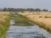
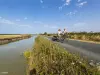
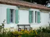
Located 30 km from Les Sables-d'Olonne, 35 km from La Roche-sur-Yon and 17 km from Luçon, the commune of Givre is located next to the Pont Rouge crossroads. It is made up of the town and various hamlets to the north towards Moutiers and to the south after the RD949.

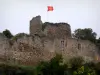
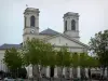
The origin of the name Le Givre comes from a place filled with vipers (same origin as La Grisse). The town was burned during the Vendée wars (church). The Château de la Brunière was rebuilt during the Renaissance on the ruins of a medieval castle.

Geographical information

MunicipalityLe Givre
Postcode85540
Latitude46.4673760 (N 46° 28’ 3”)
Longitude-1.3960450 (W 1° 23’ 46”)
AltitudeFrom 2m to 72m
Surface area12.42 km²
Population492 inhabitants
Density39 inhabitants/km²
PrefectureLa Roche-sur-Yon (28 km, 31 min)
Insee code85101
IntercommunalityCC Vendée Grand Littoral
DepartmentVendée
TerritoryPoitou
RegionPays de la Loire

Nearest cities & towns

La Jonchère4 km (8 min)
Saint-Cyr-en-Talmondais5.9 km (7 min)
Saint-Benoist-sur-Mer6.4 km (11 min)
Saint-Vincent-sur-Graon7.4 km (11 min)
Angles7.8 km (10 min)
Moutiers-les-Mauxfaits8.1 km (10 min)
Le Champ-Saint-Père8.6 km (11 min)
Le Bernard8.9 km (11 min)
Curzon9.2 km (14 min)
Avrillé10 km (11 min)
Longeville-sur-Mer11.3 km (15 min)
Saint-Hilaire-la-Forêt12.9 km (15 min)
Saint-Avaugourd-des-Landes13.2 km (16 min)
La Bretonnière-la-Claye14.3 km (18 min)

Things to see and do

The Château de la Brunière, classified as a Historic Monument for, among other things, one of its chimneys in the shape of a butter dish, its interior chimneys, its roof, its stone bridge and its well (cannot be visited).

The church, rebuilt around 1860, was renovated in the 2000s. On its square, see the tombstones serving as steps.

Three menhirs, two of which are standing, visible on the road towards La Jonchère.

Cycle loop (crossing other municipalities) “Ca Roule dans le Bocage”: 44.7 km (divisible into loops of 8 and 18 km) - Interpretation panels all along the route.

Hike (from Givre to Moutiers-les-Mauxfaits): "Around Bois Lambert" - 10.2 km - blue markings.

Events and festivities

Events organized by the school (lotto, marches, etc.) throughout the year.

Photos

Saint-Martin de Vertou Church
See photo
Château de la Brunière
See photo
Aerial view of the town
See photo

Weather

Thursday 25 april
Min. 9°C - Max. 15°C
Day
Night
Friday 26 april
Min. 10°C - Max. 15°C
Day
Night
Saturday 27 april
Min. 9°C - Max. 16°C
Day
Night

Visits, leisure and activities nearby

Leisure activities

Last nameActivity typeRateCity
Horse-drawn carriage trips in Sud-Vendée
Nature and the great outdoors175 € to 1035 € Sainte-Hermine (26 km)
Freefall skydiving in a simulator
Sports sensations45 € to 590 € La Roche-sur-Yon (26 km)
Le Grand Défi leisure park
Sports sensations22 € to 26 € Saint-Julien-des-Landes (31 km)

Outings

Last nameOuting typeDifficultyDurationDeparture municipality
Culet Loop
Cycling itineraryEasy30 minLa Tranche-sur-Mer (13.1 km)
Loop of La Grière
Cycling itineraryEasy1:15La Tranche-sur-Mer (13.7 km)
Carvor Circuit
Cycling itineraryEasy2:00La Tranche-sur-Mer (13.7 km)
Between dunes and marshes
Cycling itineraryEasy1:15La Tranche-sur-Mer (14.1 km)
The Gravelle - Champagné les Marais
HikeEasy2:05Triaize (19.6 km)

Restaurants

Bed & breakfasts

Vacation rentals

Campsites

Hotels

Your holidays
A hotel
A vacation rental
A bed & breakfast
A campsite
A leisure activity
A restaurant
A rental car
A plane ticket
By continuing to browse our site, you are agreeing to the use of cookies to improve your experience and make targeted offers.
Find out more and make settings
Your account