Liven up your holidays!

La Chapelle-en-Valgaudémar

Tourism, holidays & weekends guide in the Hautes-Alpes

La Chapelle-en-Valgaudémar - Tourism, holidays & weekends guide in the Hautes-Alpes
8.6
5

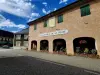
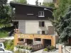
La Chapelle-en-Valgaudémar is a village in the Hautes-Alpes, in the Provence-Alpes-Côte d'Azur region, 45 km north-east of Gap.

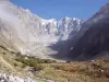
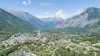
The communal territory is very vast (100 km²), and falls for a large part of the high mountain, ranging from 1022 m to 3667 m altitude. The town was born in 1963 from the merger of Clemence-Ambel and Guillaume-Peyrouse, whose very names symbolize the history of this valley, shared in the fifteenth century between the heirs of the lord of Ambel who reigned over these lands.

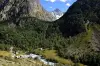
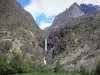
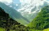
The town now covers the entire Upper Valgaudemar Valley, which crosses the Séveraise, and cuts the western Ecrins massif.

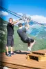
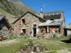
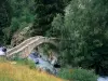
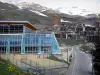
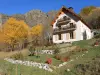
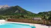
Strongly marked by the rural exodus, especially after floods in the early twentieth century that affected the cultivable land at the bottom of the valley, the village which has only one hundred inhabitants now lives mainly from tourism and dynamic impulses by the Ecrins National Park. However, there are still some farms dedicated to livestock and pastoralism.

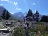
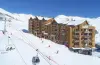
Hikers and outdoor enthusiasts in an exceptional natural setting will find in La Chapelle-en-Valgaudémar a potential to satisfy them fully, summer and winter.

Geographical information

MunicipalityLa Chapelle-en-Valgaudémar
Postcode05800
Latitude44.8169030 (N 44° 49’ 1”)
Longitude6.1952850 (E 6° 11’ 43”)
AltitudeFrom 1022m to 3667m
Surface area108.02 km²
Population108 inhabitants
PrefectureGap (47 km, 48 min)
Insee code05064
IntercommunalityCC Champsaur-Valgaudemar
DepartmentHautes-Alpes
TerritoriesAlps, Dauphiné
RegionProvence-Alps-French Riviera

Nearest cities & towns

Villar-Loubière4.7 km (8 min)
Saint-Maurice-en-Valgodemard9.4 km (14 min)
Saint-Jacques-en-Valgodemard15.1 km (25 min)
Saint-Firmin16.2 km (23 min)
Aubessagne21 km (28 min)
Aspres-lès-Corps22 km (31 min)
Beaufin24 km (31 min)
Le Glaizil26 km (36 min)
Corps27 km (36 min)
La Motte-en-Champsaur28 km (39 min)
Le Noyer29 km (40 min)
La Salette-Fallavaux31 km (40 min)
Poligny33 km (40 min)

Things to see and do

Site Oulles the Devil.

Gioberney site.

Places of interest

Leisure centres
Natural sites

Events and festivities

Annual Fair October 4 (5 if the date of October 4 is a Sunday).

Frequently Asked ewes (sheep) and the goat, the goat festive meal from that day.

Photos

Vallon of the High Séveraisse (© Jean Espirat)
See photo
Valley of the Séveraisse (© Jean Espirat)
See photo
Glacial cirque of the Condamines (© J.E)
See photo
Refuge of the Gioberney (© J.E)
See photo
Vallon des Condamines, above the Gioberney refuge (© J.E)
See photo
Oulles of the Devil (© J.E)
See photo
Haute valley of the Valgaudemar, seen from under the shelter of the Gioberney (© J.E)
See photo
Glacial cirque of the Condamines (© J.E)
See photo
Cirque of the Condamines (© J.E)
See photo
Valgaudemar Valley, view of the Gioberney road (© J.E)
See photo
Glacial cirque of the Condamines (© J.E)
See photo
Another view of the cirque des Condamines (© J.E)
See photo
Valgaudemar Valley, view of the Gioberney (© J.E)
See photo
Gioberney upper valley (© J.E)
See photo

Weather

Thursday 25 april
Min. -4°C - Max. 6°C
Day
Night
Friday 26 april
Min. -1°C - Max. 5°C
Day
Night
Saturday 27 april
Min. 2°C - Max. 9°C
Day
Night

Visits, leisure and activities nearby

On the town of Villar-Loubière, the Villar-Loubière mill (mill thatched).

Leisure activities

Last nameActivity typeRateCity
Hot air balloon flight over the Champsaur Valley
Nature and the great outdoors200 € to 1100 € Ancelle (22 km)
Refuges Sentinelles long-distance science hike
Culture and education585 € Villar-d'Arêne (27 km)
Giant zipline over the Durance Gorges
Sports sensations30 € L'Argentière-la-Bessée (29 km)
Fly fishing in Hautes-Alpes
Nature and the great outdoors150 € to 220 € Saint-Martin-de-Queyrières (31 km)
Rafting down the Durance and Cano-raft
Sports sensations38 € Saint-Clément-sur-Durance (36 km)

Outings

Last nameOuting typeDifficultyDurationDeparture municipality
Lac des Bêches from the Refuge Lavey
HikeIntermediate2:30Saint-Christophe-en-Oisans (9.1 km)
Lac des Rouies from the Lavey Refuge
HikeAthletic4:35Saint-Christophe-en-Oisans (9.1 km)
Loop of the valley of the Floors
HikeIntermediate3:20Saint-Christophe-en-Oisans (11.6 km)
Tourond Refuge
HikeEasy6:40Champoléon (11.8 km)
Lake of the Fetoules by the Refuge de la Lavey
HikeAthletic6:40Saint-Christophe-en-Oisans (13.2 km)

Restaurants

Bed & breakfasts

Vacation rentals

Campsites

Hotels

Your holidays
A hotel
A vacation rental
A bed & breakfast
A campsite
A leisure activity
A restaurant
A rental car
A plane ticket
By continuing to browse our site, you are agreeing to the use of cookies to improve your experience and make targeted offers.
Find out more and make settings
Your account