Ubaye-Serre-Ponçon is a town of Alpes-de-Haute-Provence, in the Provence-Alpes-Cote d'Azur, 37 km northwest of Barcelonnette (by road) and limits of the Hautes-Alpes.
It was formally established in January 1, 2017 following the merger of La Bréole, its seat (361 inhabitants) and Saint-Vincent-les-Forts (347 inhabitants), so now with just over 700 inhabitants.
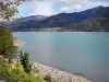
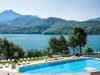
Its vast territory of 62 square kilometers bordering on ten kilometers south from Serre-Ponçon (the bank considered the "wild"), built in 1960 after the construction of a dam on the Durance whose course forms the limit "west" of the city, its limit "is" consisting of the Ubaye valley.
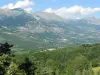
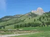
Ubaye-Serre-Ponçon of altitude ranges from 650 to 2500 m, and several peaks dominate his land overlooking the lake themselves. Largely forested, the town retains an important agricultural activity (livestock) that complement logging and now tourism, thanks to the lake and boating, a preserved environment and the proximity to the ski resort of Montclar. That makes Ubaye-Serre-Ponçon a pleasant resort.
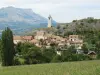
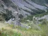
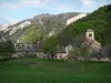
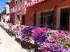
Former possession of the counts of Provence, which housed the medieval priories under the Saint-Victor de Marseille, the village of La Bréole grew to 1,000 meters, dominated by several passes to the south. The small town as its hamlets still have many old houses, with even some of the medieval elements (hamlet of the Masses).
Several parishes once shared a very rugged territory, and remains from this period four churches. In the village, the Church of St. Peter was built in the late sixteenth century bell tower was raised in the nineteenth and in 2013, the contemporary stained glass windows were installed.
On Costebelle, the Saint-Marcellin church is known to house a silver chalice dating from 1711. A La Garde, St. Bartholomew church built in 1695 retains priestly clothes ornate. Finally, at Chamarel, the Saint-Marc date of 1860 and its central span is dominated by a dome pendants.
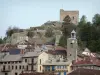
Regarding the former commune of Saint-Vincent-les-Forts, as indicated by its name, its location on a spur at 1300 m at the intersection of roads leading to Embrun and Barcelonnette earned him very soon to be seen as highly strategic.
If it now dominates the lake, the village was equipped with many fortifications: Fort of Saint Vincent (designed by Vauban in 1700 and strengthened in 1873), the Vauban tower with battlements north (1696), battery Châtelard (1883-1885) who watched the Ubaye valley remain testimonies. The village also housed a barracks, in the hamlet of Chaudon, dedicated to the soldiers who took turns in these various defensive positions or observation.
These heritage features are complemented by a number of religious buildings: the Saint-Vincent church consists of a nave vault and a double apse (XVI), the church of Lautaret and several chapels at the discretion of the territory (a tradition in the mountains because the movement of the faithful was not easy in winter).
If this heritage justifies the municipality of Ubaye-Serre-Ponçon is labeled "Country of Art and History" is now also and especially for water sports related lake, its protected environment and landscapes (peaks like Dormillouse 2500 the sometimes steep banks) that you appreciate staying there.
Large 28 km² and has a form of vertical growing, the Serre-Ponçon lake this rugged shores of the west of the territory but beaches and water bases are arranged in the east.
Besides swimming and relaxing, you can practice water skiing or jet skiing (information +33 7 63 19 62 38), sea kayaking (Contact +33 4 92 32 69 54), not including the sail (a pontoon available, to request at +33 6 33 87 40 06).
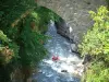
Furthermore, streams near lend themselves to rafting (join +33 4 92 32 69 54) and from the surrounding peaks, the glider is also preferred (information in +33 6 63 22 39 75).
In the village of La Bréole, outdoor pool with heated pool is open in July and August. Entrance free in the morning, pay the afternoon (3.50 euros). Information +33 4 92 95 53 58.
Finally, many hiking trails were traced and marked out on the whole territory, dotted with heritage elements (strong), shaped views of postcards on collars or the lake, at the heart of an exceptional environment (flora and fauna). Warning: some routes have significant elevation changes and are for experienced hikers. Maps and information +33 4 92 85 52 61 or +33 4 92 31 57 29.


")