


Favourite
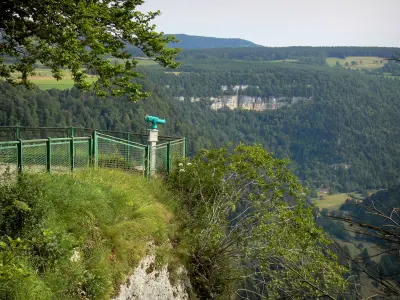
The Consolation rock formations
| Municipality | La Bosse |
|---|---|
| Postcode | 25210 |
| Latitude | 47.1377460 (N 47° 8’ 16”) |
| Longitude | 6.6503070 (E 6° 39’ 1”) |
| Altitude | From 889m to 1052m |
| Surface area | 5.13 km² |
| Population | 75 inhabitants |
| Density | 14 inhabitants/km² |
| Prefecture | Besançon (59 km, 56 min) |
| Insee code | 25077 |
| Intercommunality | CC du Plateau de Russey |
| Department | Doubs |
| Territories | Franche-Comté, Jura mountains |
| Region | Burgundy-Franche-Comté |
| Le Bizot | 2.5 km (5 min) |
|---|---|
| Le Bélieu | 2.5 km (4 min) |
| Le Mémont | 3.4 km (5 min) |
| Narbief | 4.1 km (10 min) |
| Le Luhier | 5 km (10 min) |
| Montbéliardot | 5.8 km (13 min) |
| Mont-de-Laval | 5.8 km (12 min) |
| Le Barboux | 7.5 km (16 min) |
| La Chenalotte | 8 km (14 min) |
| Le Russey | 8.1 km (12 min) |
| Fournets-Luisans | 9.1 km (17 min) |
| Fuans | 9.2 km (12 min) |
| Plaimbois-du-Miroir | 9.9 km (17 min) |
| Laval-le-Prieuré | 10.1 km (20 min) |
| Last name | Activity type | Rate | City |
|---|---|---|---|
 | Entertainment | 84 € to 110 € | Besançon (49 km) |
| Last name | Outing type | Difficulty | Duration | Departure municipality |
|---|---|---|---|---|
 | Hike | Intermediate | 35 min | Hauterive-la-Fresse (23 km) |
 | Hike | Easy | 1:00 | Pays-de-Clerval (31 km) |
 | Hike | Intermediate | 35 min | Grand-Charmont (44 km) |
 | Hike | Easy | 1:05 | La Rivière-Drugeon (45 km) |
 | Hike | Easy | 6:00 | Devecey (52 km) |


