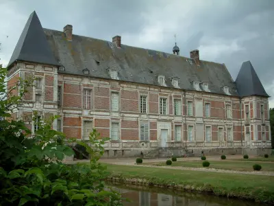
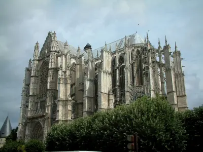
The Church of St. Mathurin is built of brick, its porch dates from the 16th century. The houses are timber framed.


Favourite
| Municipality | Haute-Épine |
|---|---|
| Postcode | 60690 |
| Latitude | 49.5827880 (N 49° 34’ 58”) |
| Longitude | 2.0119570 (E 2° 0’ 43”) |
| Altitude | From 137m to 189m |
| Surface area | 6.73 km² |
| Population | 281 inhabitants |
| Density | 41 inhabitants/km² |
| Prefecture | Beauvais (22 km, 27 min) |
| Insee code | 60304 |
| Intercommunality | CC de la Picardie Verte |
| Department | Oise |
| Territory | Picardy |
| Region | Hauts-de-France |
| La Neuville-sur-Oudeuil | 1.2 km (2 min) |
|---|---|
| Rothois | 2.5 km (5 min) |
| Prévillers | 3.2 km (5 min) |
| Oudeuil | 5.6 km (8 min) |
| Marseille-en-Beauvaisis | 5.7 km (5 min) |
| Lihus | 5.7 km (7 min) |
| Blicourt | 6.4 km (10 min) |
| Crèvecoeur-le-Grand | 6.5 km (8 min) |
| Pisseleu | 7 km (11 min) |
| Grez | 7.1 km (11 min) |
| Achy | 7.5 km (8 min) |
| Fontaine-Lavaganne | 8.3 km (10 min) |
| Hétomesnil | 9.3 km (10 min) |
| Roy-Boissy | 9.9 km (12 min) |
The Church of St. Mathurin is built of brick, its porch dates from the 16th century. The houses are timber framed.
| Last name | Outing type | Difficulty | Duration | Departure municipality |
|---|---|---|---|---|
 | Hike | Easy | 50 min | Gournay-en-Bray (24 km) |
 | Hike | Easy | 3:00 | Courcelles-sous-Moyencourt (26 km) |
| Hike | Intermediate | 4:00 | Courcelles-sous-Moyencourt (26 km) |
 | Hike | Easy | 2:00 | Paillart (26 km) |
 | Hike | Easy | 35 min | Forges-les-Eaux (34 km) |


