


Favourite
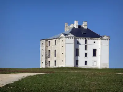
Molesme Abbey
| Municipality | Griselles |
|---|---|
| Postcode | 21330 |
| Latitude | 47.8670730 (N 47° 52’ 1”) |
| Longitude | 4.3534820 (E 4° 21’ 13”) |
| Altitude | From 197m to 284m |
| Surface area | 12.37 km² |
| Population | 90 inhabitants |
| Density | 7 inhabitants/km² |
| Prefecture | Dijon (91 km, 1:29) |
| Insee code | 21309 |
| Intercommunality | CC du Pays Châtillonnais |
| Department | Côte-d'Or |
| Territory | Burgundy |
| Region | Burgundy-Franche-Comté |
| Channay | 3 km (7 min) |
|---|---|
| Laignes | 3.5 km (5 min) |
| Nicey | 3.7 km (7 min) |
| Marcenay | 4.8 km (8 min) |
| Villedieu | 6.3 km (8 min) |
| Vertault | 7.3 km (11 min) |
| Larrey | 8.5 km (14 min) |
| Bissey-la-Pierre | 9.1 km (12 min) |
| Molesme | 9.5 km (12 min) |
| Balot | 9.8 km (13 min) |
| Gigny | 10 km (13 min) |
| Sennevoy-le-Bas | 11.1 km (15 min) |
| Fontaines-les-Sèches | 11.1 km (15 min) |
| Sennevoy-le-Haut | 11.2 km (15 min) |
| Last name | Activity type | Rate | City |
|---|---|---|---|
 | Entertainment | 30 € to 40 € | Ville-sur-Arce (28 km) |
| Last name | Outing type | Difficulty | Duration | Departure municipality |
|---|---|---|---|---|
 | All-terrain bike itinerary | Athletic | 5:40 | Mussy-sur-Seine (16.2 km) |
 | Hike | Easy | 3:25 | Courteron (18.2 km) |
 | Hike | Intermediate | 5:20 | Étourvy (19.4 km) |
 | All-terrain bike itinerary | Athletic | 4:40 | Essoyes (25 km) |
 | All-terrain bike itinerary | Easy | 5:15 | Chaource (27 km) |


