Grainville-sur-Odon has existed as a commune since the revolutionary decree of November 12, 1789. Previously, the land belonged to the Seigneurie de Grainville, owned by the De Lacourt family. Charles de Lacourt Grainville was also mayor of the town.
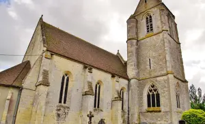
The oldest municipal buildings are the church, located in the heart of the village, built in the 13th and 14th centuries, and the castle of Belval, located north of the town towards Cheux, dating back to from the 17th and 18th centuries.
The bell tower and the choir of the church have been listed in the inventory of historical monuments since 1910.
The current departmental road n ° 675, which provides access from Missy to Mondrainville has long been the structuring axis of the town insofar as it separates the town from the hamlets located to the south. Previously the national road (n ° 175), it has undoubtedly contributed to the development of the town, especially at the level of Valtru. Built in the 1820s, the road allowed Caennais to reach the coast of the south of the Channel, Mont-Saint-Michel and Saint-Malo (hence its nickname Route de Bretagne). Grainville then represented an interesting stopover halfway between Caen and Villers-Bocage, then popular for its cattle market.
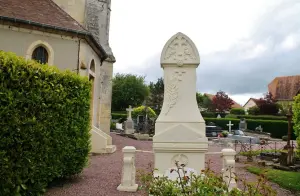
The Calvary located at the crossroads of rue de Friborg and rue de Carrouges was erected in 1935. Its surroundings were redesigned when the roundabout was put in place.
The Saint Pie X school was opened on October 28, 1869 in the building built 40 years earlier by the Delacourt Grainville family (descendants of the former lords of Grainville), following the will of Mlle Cécile Delacourt Grainville to the religious community of the Holy Heart of Mary. Initially reserved for young girls, the school was made mixed in 1943.
The building having been completely destroyed by the bombardments in June 1944, education continued in temporary premises; the school will not be rebuilt until 1954 and inaugurated in September 1958. It was on this occasion that it was named after the two hundred and fifty-seventh Catholic Pope.
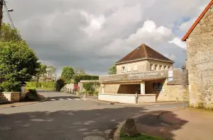
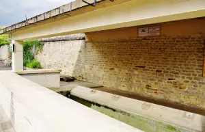
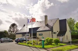
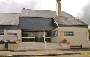
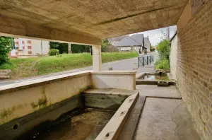
The statue of Our Lady of the Sacred Heart was installed in 1870, to signify the entrance to the school and allow the schoolchildren of the time to meditate there. Initially located in the middle of the central median facing the wash house, it was moved to the Maison des Associations in 1980. The latter, built in 1906, served as the town hall until the inauguration of the current municipal seat in 1981.
On August 22, 1886, the Caen - Vire railway line was inaugurated in its Caen - Saint Georges d'Aunay section. Located in place of the current A84 motorway, it isolates the hamlets of Salbey and Belval, to the north, from the rest of the town.
The town is then not served by a station, but residents of Grainville can easily take this new means of transport from Mondrainville station. Unfortunately, passenger transport on this railway line will cease on March 1, 1938. Freight will continue until April 1972 and the line will be permanently decommissioned in 1975.
Grainville during World War II:
In 1940, the school (future Saint Pius X) served as shelter for several months for refugees and in particular for orphans from the Ouvroir Notre Dame de Caen and their mistresses.
Under Occupation, the school was open to boys and had around fifty students. From mid-June 1944, with the approach of the fighting, all Grainville residents were forced to evacuate the village.
The liberation of Grainville-sur-Odon in 1944 is part of Operation "Epsom" led by British and Canadian troops to break through the German front bypassing Caen from the west. The Allies intend in particular to seize the 3 strategic bridges over the Odon to ultimately liberate the regional capital. In fact, due to its steep-sided topography, the Odon river can only be crossed by vehicles by the Méhaye bridge (which connects Grainville to Gavrus), the Pont Neuf (limit between Mondrainville and Gavrus in the heart of the Bois des Amis de Jean Bosco) and the Tailleboscq bridge (which connects Tourville to Baron sur Odon).
The operation was launched on June 25, 1944 by General Montgomery, with a contingent of 60,000 soldiers and 600 tanks. The next day, the allies were up to Fontenay le Pesnel. The Canadian troops progressed at good speed towards Saint Manvieu-Norrey and the 15th Scottish infantry division liberated Cheux, where many battles took place. On the evening of June 26, Allied soldiers pushed back the German front up to the Route de Bretagne, where the fighting concentrated on the following days.
Further west, the progression is more difficult; Bitter discussions took place on June 26 in the neighboring village of Rauray, in the immediate vicinity of the Grainvillais localities of Belval and Salbey.
Very briefly, a sanitary control zone was set up in the school and its principal at the time will be the last inhabitant to leave Grainville on June 29.
Several bombings will be carried out on the town: the school will be completely destroyed on June 29 in the afternoon and the church and the castle of Grainville will also be affected.
The fighting fades after June 29 and the Allies seize the 2 bridges over the Odon allowing Gavrus to rally. However, the village will not find immediate calm since the fighting will continue south of the Odon until July 16, 1944 (date of the liberation of Gavrus).
The vestiges of this painful past sometimes resurface, as in the early 2000s, when the bodies of 2 German soldiers were found in the north bend of the rue des Trois Buttes, or as in June 2012, when 'a shell was discovered near the recreation area.
The evolution of Grainville over the past 50 years:
Like many French municipalities, the past 50 years have profoundly changed the landscape of Grainville.
In the mid-1970s, Grainville acquired its water tower. This new high point then becomes a landscape landmark visible from the surrounding high points (Cheux, "hill 112" between Evrecy and Gavrus, etc.).