Liven up your holidays!

Glos-sur-Risle

Tourism, holidays & weekends guide in the Eure

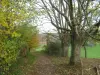
Bordered by the forest of Montfort (300 ha) and crossed by the Risle, this town has all the characteristics of the valley of the Risle. It houses one of the finest medieval remains of Haute-Normandie.

They say that district owes its origin to the erection of a church built in the valley in expiation of a huge massacre. It is difficult to explain the name of this town: it could have the same root as the word gloarius (logger).

The Roman road from Brionne Juliobona to Lillebonne across the territory of Glos. We find there are other memories of that time: thirty tombs of stone, clay vases containing, amongst the bones and hatchets Gallic.

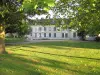
The capital of the manor of Glos was with the church at the entrance of the prairies. The castle was later rebuilt a little further to Montfort. The old location is still marked by a dovecote and a construction of the 12th century. It was a novel that mansion would have been before a religious vocation: a stately chapel, now preaches the 16th century. He served as a place of worship to Protestants in the 16th century, and if we are to believe certain texts, a massacre of 11 Protestants was committed during the war of religion. Currently located on private property, the manor and the pigeon are classified historical monument.

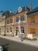
The parish church has retained its ancient architecture, its semicircular apse and the arch lowered the entry of the choir. Its patron Saint Vincent and the Holy Trinity.

The Lordship of Glos-sur-Risle was owned successively Tournebu families and the Sec of Cosimo, and finally, Rupière.

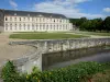
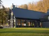
One of the strongholds of Glos Sahurs, has a castle built Grente family, lord of this place, in the late 18th century. Castle Sahurs is currently private property of the Marquis de Durfort.

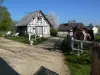
Because of its geographical position, near the Risle, Glos had a strong textile industry. Water power available to run two flour mills, a woolen mill and two mills flax.

Geographical information

MunicipalityGlos-sur-Risle
Postcode27290
Latitude49.2700050 (N 49° 16’ 12”)
Longitude0.6810040 (E 0° 40’ 52”)
AltitudeFrom 31m to 135m
Surface area7.33 km²
Population618 inhabitants
Density84 inhabitants/km²
PrefectureEvreux (49 km, 54 min)
Insee code27288
IntercommunalityCC de Pont-Audemer / Val de Risle
DepartmentEure
RegionNormandy

Nearest cities & towns

Thierville3.5 km (7 min)
Pont-Authou3.7 km (5 min)
Montfort-sur-Risle3.8 km (5 min)
Saint-Philbert-sur-Risle4.9 km (7 min)
Authou5.5 km (9 min)
Le Bec-Hellouin5.7 km (8 min)
Freneuse-sur-Risle6 km (10 min)
Écaquelon6 km (12 min)
Livet-sur-Authou7.5 km (12 min)
Condé-sur-Risle7.9 km (14 min)
Malleville-sur-le-Bec8.1 km (12 min)
Saint-Léger-du-Gennetey8.2 km (10 min)
Bonneville-Aptot8.3 km (10 min)

Things to see and do

Places of interest

Transport

Weather

Friday 19 april
Min. 6°C - Max. 13°C
Day
Night
Saturday 20 april
Min. 3°C - Max. 11°C
Day
Night
Sunday 21 april
Min. 2°C - Max. 11°C
Day
Night

Visits, leisure and activities nearby

Green Lane Bridge-connecting Authou in Evreux, 40 km trail reserved for cyclists, skaters and other hikers.

Bicycle Rental Solidarity with the Tourist Pole (information on +33 2 32 43 93 80).

Leisure activities

Last nameActivity typeRateCity
Cookery lessons at La Maison du Chef Normand
Local flavours55 € Saint-Philbert-des-Champs (30 km)
Historical train ride with a steam locomotive
Entertainment40 € Sotteville-lès-Rouen (34 km)
Guided bike tour in Deauville and Trouville sur Mer
Culture and education130 € Deauville (44 km)
Electric bike excursion in Calvados
Entertainment40 € to 245 € Deauville (45 km)
Bike and scooter hire and delivery
Sports sensations15 € to 190 € Trouville-sur-Mer (45 km)

Outings

Last nameOuting typeDifficultyDurationDeparture municipality
Medieval legacy in the Val de Risle
Cycling itineraryEasy4:00Montfort-sur-Risle (3 km)
Saracens Path
HikeEasy3:00Condé-sur-Risle (7 km)
Heritage tour - city of Pont Audemer 27500 Normandy
HikeEasy35 minPont-Audemer (15.2 km)
The Fruit Route in the Anneville Loop
Cycling itineraryAthletic2:05La Bouille (20 km)
Jumièges Loop - Equestrian Route
Horse rideEasy2:05Jumièges (20 km)

Restaurants

Bed & breakfasts

Vacation rentals

Campsites

Hotels

Your holidays
A hotel
A vacation rental
A bed & breakfast
A campsite
A leisure activity
A restaurant
A rental car
A plane ticket
By continuing to browse our site, you are agreeing to the use of cookies to improve your experience and make targeted offers.
Find out more and make settings
Your account