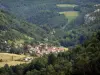
Common north of the Doubs valley, bordering Switzerland and formed by the combination with Montursin and Vernois-le-Fol.


Favourite


Common north of the Doubs valley, bordering Switzerland and formed by the combination with Montursin and Vernois-le-Fol.
| Municipality | Glère |
|---|---|
| Postcode | 25190 |
| Latitude | 47.3438580 (N 47° 20’ 38”) |
| Longitude | 6.9943840 (E 6° 59’ 40”) |
| Altitude | From 404m to 903m |
| Surface area | 15.93 km² |
| Population | 193 inhabitants |
| Density | 12 inhabitants/km² |
| Prefecture | Besançon (113 km, 1:27) |
| Insee code | 25275 |
| Intercommunality | CC du Pays de Maîche |
| Department | Doubs |
| Territories | Franche-Comté, Jura mountains |
| Region | Burgundy-Franche-Comté |
| Burnevillers | 5.7 km (10 min) |
|---|---|
| Vaufrey | 6.7 km (10 min) |
| Indevillers | 7.9 km (12 min) |
| Montancy | 8.3 km (12 min) |
| Montjoie-le-Château | 8.9 km (13 min) |
| Courtefontaine | 12.5 km (18 min) |
| Les Plains-et-Grands-Essarts | 13.3 km (19 min) |
| Soulce-Cernay | 13.9 km (19 min) |
| Villars-lès-Blamont | 15.8 km (27 min) |
| Trévillers | 16.8 km (24 min) |
| Pierrefontaine-lès-Blamont | 18.4 km (29 min) |
| Thiébouhans | 18.4 km (26 min) |
| Goumois | 18.9 km (34 min) |
| Dannemarie | 19 km (34 min) |
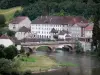
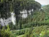
The area has many hiking trails.
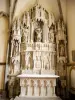
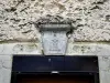
A Glère: Church of the 17th century fountain and laundry.
A Vernois Fontaine and laundry.
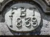
In the hamlet of Fol: Chapel 1872 and laundry.


| Last name | Outing type | Difficulty | Duration | Departure municipality |
|---|---|---|---|---|
 | Hike | Intermediate | 35 min | Grand-Charmont (23 km) |
 | Hike | Easy | 1:00 | Pays-de-Clerval (38 km) |
 | Hike | Intermediate | 1:00 | Burnhaupt-le-Haut (44 km) |
 | Village visit | Easy | 1:00 | Masevaux-Niederbruck (48 km) |
 | Hike | Intermediate | 3:00 | Masevaux-Niederbruck (48 km) |