The village, located on the right bank of Lembronnet 380 m above sea level, is located beneath the southwest edge of the basalt plateau or Chaux du Broc, from which a panoramic view on the plain of Lembron.
The name of Gignat come from the surname Gennius and acum suffix. Another source said that the word seems to be derived from a Gallic word gena : mouth bowl outlet.
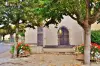
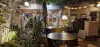
Gignat village retains a significant architectural heritage.
The old houses that still spot by architectural elements from the late Middle Ages and early modern era ( fourteenth to sixteenth centuries).
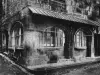
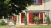
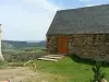
Old wine village Gignat keeps winegrowers' houses, one can also notice numerous dovecotes of different forms : single specific buildings or integrated in the outbuildings of the houses.
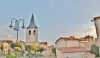
The church is a small Romanesque building with a single nave very revamped broken gate, side windows of lobed bedside truncated on their bottom.
Concerning natural heritage : the tip of Gignat lime southeast of the town, is an area of ecological interest, with 182 different plants identified, including many species of orchids, some of which are protected.
A 3 km north - west is the town that has Mareugheol in the town center a strong villagers : it forms an almost perfect square of 65 m square with four round towers at the corners.
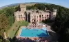
A 3 km west, the castle of Villeneuve- Lembron was built in the late 15th century. It is built around a square courtyard with four towers at each corner and surrounded by moats. Amazing murals in the 15th and 16th centuries.
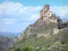
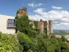
Continuing 2 km south is visible the village of Chalus. The castle is reported from the 10th century and has an old cadastral chapel of Roman origin altered several times. At the foot of the hill towards Gignat is the Sainte-Madeleine chapel built in arkose and basalt. The winemaking tradition is perpetuated in this village ( Auvergne wine).
To the south -west 6 km, the wine village of Boudes (wine Auvergne Boudes coast ) has many features with its church classified historical monuments ( 12th century ) opening the " Quartier des Forts ". Furthermore it is possible to visit a territory that covers 27 ha, classified sensitive natural area by the General Council of Puy-de-Dôme, called " Valley of Saints," alternating a dry forest and training remarkable geological : fairy chimneys, circuses and multicolored cliffs. For this a 5.8 km circuit was built on which is also present a salty source.
10 km south -west still, the village of Saint-Gervazy has a 13th century castle that houses a museum of the horse toy.
Head south about 6 km, is the village of Vichel dominated by the peak of Montcelet the remarkable panorama, on top of which a tower ( remains of a fortress of the 9th and 10th centuries ) was restored.
Southeast side about ten kilometers from the top of the hill of Nonette, another breathtaking panorama offers an almost aerial view of the village and Lembron. In the village, the Horts park is home to several species of trees.
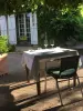
Besides churches and castles visible throughout the Lembron Community of Communes Val d'Allier, many fountains are present as well as pigeon or restored bread ovens. In this area where vines had and still has a recognized place, it is possible to contemplate typical winegrowers' houses.