
Favourite
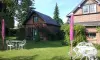
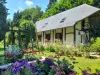
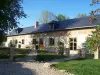
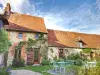
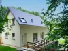
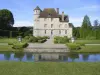
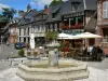
Vascoeuil Castle
| Municipality | Fry |
|---|---|
| Postcode | 76780 |
| Latitude | 49.5295050 (N 49° 31’ 46”) |
| Longitude | 1.5263300 (E 1° 31’ 35”) |
| Altitude | From 108m to 216m |
| Surface area | 8.03 km² |
| Population | 145 inhabitants |
| Density | 18 inhabitants/km² |
| Prefecture | Rouen (48 km, 45 min) |
| Insee code | 76292 |
| Intercommunality | CC des 4 Rivières |
| Department | Seine-Maritime |
| Region | Normandy |
| Le Mesnil-Lieubray | 1.8 km (2 min) |
|---|---|
| Argueil | 2 km (4 min) |
| Mésangueville | 4 km (7 min) |
| Sigy-en-Bray | 4.9 km (8 min) |
| La Hallotière | 5.3 km (8 min) |
| Hodeng-Hodenger | 5.4 km (8 min) |
| Beauvoir-en-Lyons | 5.7 km (7 min) |
| Nolléval | 5.8 km (6 min) |
| Rouvray-Catillon | 7.3 km (11 min) |
| La Ferté-Saint-Samson | 7.7 km (10 min) |
| Brémontier-Merval | 8.3 km (11 min) |
| Saint-Lucien | 9 km (12 min) |
| Saumont-la-Poterie | 10 km (17 min) |
| Last name | Activity type | Rate | City |
|---|---|---|---|
 | Entertainment | 40 € | Sotteville-lès-Rouen (33 km) |
 | Nature and the great outdoors | 12 € to 16 € | Saint-Denis-sur-Scie (34 km) |
| Last name | Outing type | Difficulty | Duration | Departure municipality |
|---|---|---|---|---|
 | Hike | Intermediate | 1:30 | La Hallotière (4.1 km) |
 | Hike | Easy | 2:15 | La Feuillie (7.4 km) |
 | Cycling itinerary | Athletic | 2:45 | Forges-les-Eaux (8.8 km) |
 | Car itinerary | Easy | 1:05 | Forges-les-Eaux (8.8 km) |
 | Hike | Easy | 35 min | Forges-les-Eaux (9.4 km) |