

Favourite
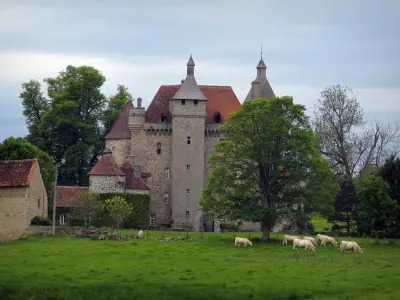
The Boussac castle


| Municipality | Domeyrot |
|---|---|
| Postcode | 23140 |
| Latitude | 46.2509260 (N 46° 15’ 3”) |
| Longitude | 2.1560000 (E 2° 9’ 22”) |
| Altitude | From 333m to 520m |
| Surface area | 24.59 km² |
| Population | 236 inhabitants |
| Density | 9 inhabitants/km² |
| Prefecture | Guéret (30 km, 28 min) |
| Insee code | 23072 |
| Intercommunality | CC Creuse Confluence |
| Department | Creuse |
| Territories | Limousin, Massif Central |
| Region | New-Aquitaine |
| Saint-Silvain-sous-Toulx | 2.5 km (5 min) |
|---|---|
| Parsac-Rimondeix | 6.2 km (9 min) |
| La Celle-sous-Gouzon | 6.6 km (9 min) |
| Blaudeix | 8.5 km (12 min) |
| Jalesches | 10.1 km (15 min) |
| Clugnat | 10.3 km (13 min) |
| Toulx-Sainte-Croix | 10.3 km (15 min) |
| Ladapeyre | 10.5 km (14 min) |
| Gouzon | 10.9 km (17 min) |
| Trois-Fonds | 11.3 km (18 min) |
| Jarnages | 11.4 km (18 min) |
| Malleret-Boussac | 12.6 km (19 min) |
| Gouzougnat | 12.7 km (20 min) |
| Châtelus-Malvaleix | 13 km (19 min) |


| Last name | Outing type | Difficulty | Duration | Departure municipality |
|---|---|---|---|---|
 | Car itinerary | Easy | 1:00 | Ahun (20 km) |
 | Hike | Easy | 2:00 | Chambon-sur-Voueize (22 km) |
 | Hike | Easy | 3:00 | Moutier-Malcard (23 km) |
 | Car itinerary | Easy | 1:35 | Évaux-les-Bains (27 km) |
 | Hike | Intermediate | 2:20 | Évaux-les-Bains (27 km) |


