Créhen is a commune in the Côtes-d'Armor department, in the Brittany region, 19 km northwest of Dinan.
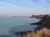
Its territory of 18 km² is located on the right bank of the coastal river Arguenon, which constitutes its "western" limit up to the edge of its mouth into the English Channel. To the south, the municipal boundary is made up of the Montafilan stream.
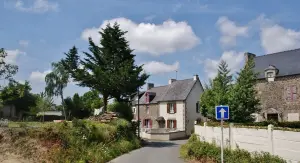
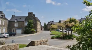
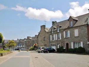
Covered with arable land (45% of its surface area), various agricultural areas (30%) and meadows (14%), the locality is made up of a town bordering the Arguenon and several hamlets and places -said including Le Guildo, to the north, on the coast, famous for its castle.
Occupied since the Neolithic, as evidenced by several megalithic remains (dolmens, covered funerary paths), Créhen developed after the year 1000.
A first Guildo castle is then mentioned, and the first church of the village is cited in a papal bull in 1163 as a possession of the abbey of Saint-Jacut.
At the end of the Middle Ages, Gilles de Bretagne who held the Château du Guildo was arrested because he was an ally of the English. Nearby, in 1864, a bridge was built which spanned the Arguenon and facilitated traffic on the coast. Previously, in Créhen, long a simple fishing village, the congregation of the Daughters of Divine Providence was created in 1822.
Today, the town has nearly 1,700 inhabitants and highlights the charms of its coastal landscapes, its heritage and its leisure offerings. Close to famous sites and beaches, Créhen appeals to vacationers looking for authenticity.
A stop at set of around twenty orthostats (standing stones) partly surmounted by tables (placed stones form a cover). This funerary site testifies to a human presence since the Neolithic period.
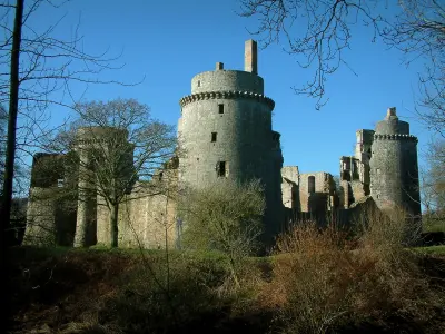
Then head to the mouth of the Arguenon and Château Guildo. Monitoring the estuary and the coast from a promontory, the place was already renowned in Prehistory and then Antiquity, but it was around the year 1000 that a first fortified building was attested. A second, larger one was rebuilt at the beginning of the 13th century, whose fortified walls follow the rocks. The wars of succession of the Duchy of Brittany led to its destruction and we had to wait until the end of the 14th century to see the reconstruction of the castle. It then belonged to Charles de Dinan, close advisor to the Duke. A large part of the walls still visible date from this period. A large dwelling then occupies the north and east sides. The outbuildings lean against the “west” wall. The castle then underwent several phases of work to expand the accommodation. In the middle of the 15th century, the premises were occupied by Gilles de Bretagne, brother of the Duke and husband of Françoise de Dinan. After Gilles' death, she became Countess of Laval and lost interest in the castle. A garrison was resettled there in 1488 in anticipation of the war against France. The fighting left the castle half ruined. It was rebuilt around 1490 and adapted for gunpowder artillery. Besieged during the Wars of Religion, the building was abandoned even before the Revolution. In 1981, the castle which served for a time was acquired by the Department. Excavations are carried out and its restoration is completed in 2021. Highlighted, its remains occupy an area of 5 hectares. It is open to visitors and in season, activities, concerts and shows are scheduled there. Information on +33 2 96 62 27 82.
In addition to the remains of the Château de la Touche-à-la-Vache (15th century), to the south of the town this time, in the village, to be seen next, the Community house of Divine Providence, a congregation founded in Créhen in 1822 to "serve the poor" and teach. The site (built in the 19th century) still houses several dozen nuns and a retirement home. The places are also open to the public for retreats or times of reflection. Contact on +33 2 96 84 14 51.
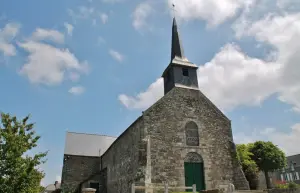
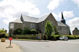
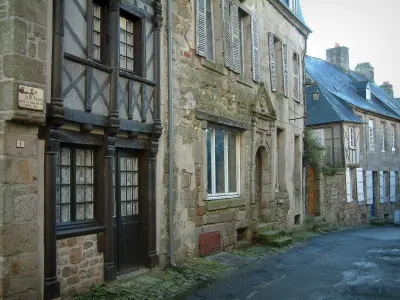
Also in the village, the Saint-Pierre parish church was rebuilt (in schist and sandstone) from 1817 to 1831 while retaining elements of Romanesque origin, such as the portal surmounted by a lintel supported by columns with capitals. The building follows a plan in the shape of a Latin cross, the "west" wall, supported by buttresses, being crowned with a square bell tower topped by a polygonal spire.
Several manor houses have become the centers of agricultural estates, a number of chapels, crosses and mills still mark a stroll through the territory, along the paths and localities.
Then make way for the many “nature” leisure activities available in the locality.
The Cap à l'Ouest association offers various outdoor activities (kayak, Nordic walking, mountain biking, etc.) to enjoy the coastline and the hinterland of the Emerald Coast. The walks are done in small groups. Open from February to mid-November. Contact +33 6 66 56 94 02.
Traveling the countryside between land and sea is also the vocation of the local Emeraude cyclo-VTT club (contact +33 6 17 44 95 46), and in an equally bucolic way, and on the back of horse, from the Jannais equestrian center (information on +33 6 71 59 45 43).
For hikers who wish to "walk" freely, several routes are marked in the town. They all have the same starting point: the multipurpose room located on rue de la Champagne. Four loops are available: “Entre et Mer” goes around the area, notably following the river bank and returning inland after Le Guildo (18 km); “la Campagne” highlights rural landscapes (12.5 km); "the Bourg loop" is more modest (4.3 km) and finally that of the Dolmens is focused on the observation of Neolithic remains (10.5 km).
Still in terms of hiking, you can take the famous Douaniers trail (GR 34) from the north of the territory and thus reach the beaches of nearby towns or even follow secure paths punctuated with viewpoints and heritage sites the seaside resorts of Saint-Caast, Saint-Briac or Dinard… Maps and information from the town hall on +33 2 96 84 13 12 or from the intercommunal tourist office on +33 8 25 95 01 22.


")