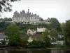
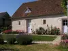
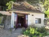
Souday:
Classified church.
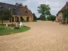
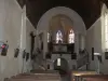
Arville:
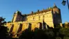
The Templar Commandery of Arville.

| Municipality | Couëtron-au-Perche |
|---|---|
| Postcode | 41170 |
| Latitude | 48.0363130 (N 48° 2’ 11”) |
| Longitude | 0.8649190 (E 0° 51’ 54”) |
| Altitude | From 106m to 240m |
| Surface area | 86.47 km² |
| Population | 1053 inhabitants |
| Density | 12 inhabitants/km² |
| Prefecture | Blois (69 km, 1:18) |
| Insee code | 41248 |
| Intercommunality | CC des Collines du Perche |
| Department | Loir-et-Cher |
| Territories | Loire Valley, Orléanais |
| Region | Centre-Loire Valley |
| Mondoubleau | 7.4 km (8 min) |
|---|---|
| Le Plessis-Dorin | 8.2 km (16 min) |
| Cormenon | 8.5 km (10 min) |
| Boursay | 9 km (14 min) |
| Valennes | 9.2 km (19 min) |
| Melleray | 9.7 km (11 min) |
| Choue | 10.2 km (12 min) |
| Montmirail | 11.2 km (14 min) |
| Baillou | 11.6 km (16 min) |
| Saint-Marc-du-Cor | 12.2 km (16 min) |
| Vibraye | 12.7 km (16 min) |
| Berfay | 12.7 km (23 min) |
| Le Gault-du-Perche | 13.4 km (16 min) |
| Rahay | 13.6 km (19 min) |
Classified church.
The Templar Commandery of Arville.
| Monuments | |
|---|---|
| Natural sites |
Brocante the 1st weekend of July.
Grand Stock-car every year in September.
Former Templar to Arville.
| Last name | Activity type | Rate | City |
|---|---|---|---|
 | Sports sensations | 120 € to 220 € | Villefrancoeur (47 km) |
| Last name | Outing type | Difficulty | Duration | Departure municipality |
|---|---|---|---|---|
 | Cycling itinerary | Easy | 2:00 | Lunay (26 km) |
 | Village visit | Easy | 1:00 | Châteaudun (35 km) |
 | Hike | Easy | 3:00 | Châteaudun (35 km) |
 | Hike | Easy | 55 min | Bonnétable (36 km) |
| Hike | Intermediate | 2:45 | Nonvilliers-Grandhoux (41 km) |