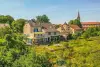
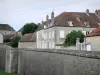
- Coiffy Cellars: Tasting and visit the ancient cellars. Introduction to oenology for groups.
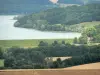
- Hiking: Several tours on the slopes of Coiffy through its vineyard - Passage of GR7 and Camino de Santiago.

Favourite
| Municipality | Coiffy-le-Haut |
|---|---|
| Postcode | 52400 |
| Latitude | 47.9067440 (N 47° 54’ 24”) |
| Longitude | 5.6968910 (E 5° 41’ 49”) |
| Surface area | 9.65 km² |
| Population | 108 inhabitants |
| Density | 11 inhabitants/km² |
| Prefecture | Chaumont (55 km, 56 min) |
| Insee code | 52136 |
| Intercommunality | CC des Savoir-Faire |
| Department | Haute-Marne |
| Territory | Champagne-Ardenne |
| Region | Great East |
| Montcharvot | 3.8 km (6 min) |
|---|---|
| Coiffy-le-Bas | 4.2 km (8 min) |
| Laneuvelle | 5.3 km (10 min) |
| Chézeaux | 6.1 km (8 min) |
| Champigny-sous-Varennes | 7.7 km (13 min) |
| Bourbonne-les-Bains | 7.9 km (13 min) |
| Soyers | 8.7 km (11 min) |
| Guyonvelle | 8.8 km (10 min) |
| Varennes-sur-Amance | 9.9 km (14 min) |
| Arbigny-sous-Varennes | 10.5 km (14 min) |
| Voisey | 11.2 km (17 min) |
| Laferté-sur-Amance | 11.2 km (13 min) |
| Vicq | 12.1 km (18 min) |
On January 22, the feast of Saint Vincent Coiffy-le-Haut, Mass enthronement festivities.
| Last name | Outing type | Difficulty | Duration | Departure municipality |
|---|---|---|---|---|
 | Cycling itinerary | Easy | 3:20 | Neuilly-l'Évêque (19.1 km) |
 | Hike | Easy | 4:30 | Chauffourt (22 km) |
 | Hike | Intermediate | 7:30 | Chalindrey (22 km) |
 | Cycling itinerary | Intermediate | 2:55 | Chalindrey (23 km) |
 | Cycling itinerary | Easy | 1:50 | Peigney (24 km) |