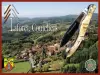
Cherier is a commune in the Loire department, in the Auvergne-Rhône-Alpes region, 17 km southwest of Roanne.
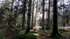
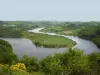
Its territory of 28 km², bordering the northwest of Allier, ranges from 594 to 1156 m above sea level. It belongs to the Urfé region and provides the transition between the southern part of the Bois Noirs and Madeleine massifs and the Roanne plain.
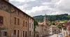
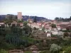
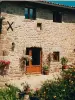
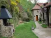
Covered mainly by meadows (54% of its surface area) and forests (35%), the locality specializing in livestock farming has the specificity of having two "centers": the old town of Vieux Cherier, in the northeast, appreciated for its views of the plain but away from the communication routes and the more central town of Moulins-Cherier, which developed in the 19th century along the road linking Roanne to Clermont.
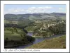
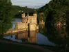
Mentioned before the Year 1000, with a Romanesque church whose bases date from the 11th century (in the old town), Cherier is renowned for its hydrographic richness which makes it a real water tower. Thanks to the reservoirs on the course of the Isable, the surrounding towns downstream benefit greatly from it!
Its relief and its natural environment will delight lovers of green tourism, Cherier (570 inhabitants) with a potential of 100 km of marked trails on its territory!
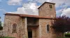
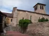
In terms of heritage, it is in the village of Vieux Cherier that the jewel of the town is located: its Sainte-Marie church is considered one of the oldest in the department. The choir was built in the 11th century and the nave was fitted out in the 12th century. Listed in the Inventory, restored according to the rules of the art in the 1980s, the Romanesque style church has a very charming side entrance preceded by a covered hall where the faithful could linger after the service. The building houses wall frescoes from the early Middle Ages, unearthed quite recently, and a polychrome wooden Christ from the 12th century which is a real treasure of sculpture.
In addition to a few traditional dwellings, to see nearby, to the south-east, is the Salette chapel. If the building which houses a Madonna was only erected in 1867 on the return from a pilgrimage, the site is worth for its location, a veritable balcony overlooking the plain of Roanne and from which, on a clear day, we can see the Alpine peaks and Mont Blanc. An orientation table has been installed. According to local tradition, from the old town as well as from the chapel, we can count no less than 72 bell towers!
A heritage discovery trail then leads to the southwest towards the town of Moulins (or Moulins-Cherier): at the confluence of the Mardan stream with the Isable river, along the departmental road, this second center developed in the 19th century around a church dedicated to Saint-Barthélemy erected from 1844. Furthermore, as its name indicates, mills were operated there (at least six when the activity flour mill and the energy needs of artisans were at their peak…).
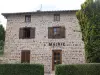
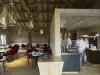
In terms of leisure activities, let us mention the Jean Brunelin village hall which hosts community activities and shows throughout the year: information at the town hall on +33 4 77 63 14 67.
Next, there is a very rich accessible potential on the locality for hikers. A network of 100 km of marked paths maintained by an association is available, i.e. 9 loops ranging from 3 to 35 km long! One of them, 28 km long, is also open to mountain bikers.
These mostly unpaved routes are dedicated to discovering the rich nature of the local countryside, its valleys, its reliefs, its wooded plots and its meadows. The landscapes which change with the seasons (covered with snow in winter), the elements of small rural heritage, a few hamlets and charming viewpoints thus punctuate the walks between mountains and plains.
A guide is available at the town hall. Routes can also lead to Roanne or the summits of Bois Noirs.
Maps and information on +33 4 77 63 14 67 or from the intercommunal tourist office on +33 4 77 71 51 77.
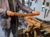
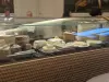
Along the way, stops are welcome at local producers. Let us cite the Gaec du Menhir at a place called La Vialle specializing in Charolais heifers and milk-fed calves (contact +33 4 77 63 33 07), the Isable farm at a place called Point du Jour which produces chickens, lambs and squabs (contact +33 4 77 63 32 29), the artisan jam shop of Vieux (information on +33 6 82 33 89 72) and the Bouchet agroecological farm (sheep, wild plants, wheat and rye flour: contact +33 4 77 63 12 77).
For amateurs, note that a paraglider launch site at the Roches de Sainte-Agathe near the old town is accessible, maintained by the Roanne club. It is reserved for graduates (no courses or "baptisms"...). Information on +33 6 42 19 53 10.
Pentecost Monday, group hike.
The first weekend in August, patronal festival with pétanque competition, shows, meals, ball, garage sale (Sunday) and fireworks.
The second Friday in December, Christmas market.