


Chatelaudren:
- His situation :
- Small town of 46 hectares, Châtelaudren is the old capital of Goëlo and the chief town of the canton.
- Crossed by Leff, the border river between Pays Breton and Pays Gallo, Leff Communauté, community of communes of Châtelaudren-Plouagat, extends over a vast land of groves.
- To the west of the river is proudly the Argoat, the country of the woods, where hills and valleys follow one another, while to the east the Armor, the land of the sea, peacefully lets down its relief towards the coast. Crossing of two cultures, Breton and Gallese, the Country of the Leff was enriched by this miscegenation which made of this country a land of reception and tolerance.
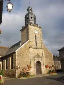
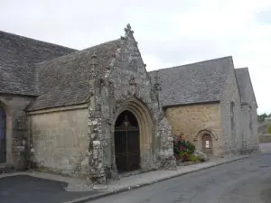
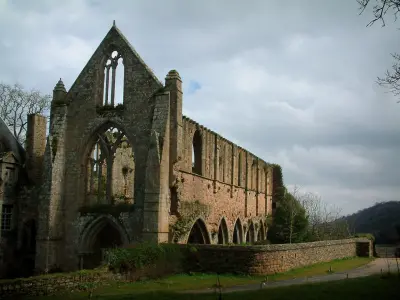
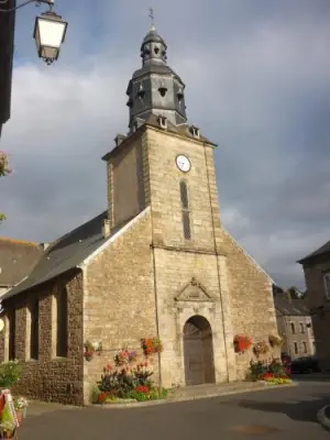
- Classified as "Small City of Character", Châtelaudren pursues its commercial vocation around its rich 18th century facades, its chapel Notre-Dame du Tertre and its extremely rare 15th century painted paneling, or the printing press. "Petit Echo de la Mode", which has dressed all over France where we can now regularly visit high quality exhibitions. But the capital of Goëlo in no way eclipses the 12 surrounding communes which, furrowed by small hiking trails, offer a rich historical heritage. Castles, mansions, churches, chapels and archaeological sites are all invitations to the walk. In short, the territory enjoys an exceptional geographical location combining the maritime proximity and the foothills of the Armorican massif, it is also close to the cities of Saint-Brieuc and Guingamp and appears as a perfect home port to discover Brittany.
- A little history :
- The history of Châtelaudren begins on a site occupied since the Neolithic, at the crossroads of the old ways, on a promontory at the edge of the river. Which would have known in medieval times the implantation of a feudal mound. It is here, would have been built in the eleventh century, probably around 1040, the castle of Count Audren, now gone, but to whom the city owes its name: Castelaudren.
- Later, around 1060, Count Audren's son, entrusted to the monks of the abbey of Saint Magloire de Léhon, a land below the fortification, to create the priory Saint Magloire and the town. In 1151, the priory is erected in parish. Formed from a dismemberment of Plouagat and Plélo, it depends, east of Leff, the bishopric of Saint-Brieuc, and west of that of Tréguier.
- In 1202, the church became possession of the abbey of Beauport. A few years later, Châtelaudren became the county seat of Goëlo County and the Baronnie d'Avaugour. The stronghold of the barony of Avaugour is dismantled for the first time in the 13th century and rebuilt by the powerful lords of Penthièvre.
- After the War of Succession, in 1422, the town and castellany of Châtelaudren became the possession of the future Duke of Brittany, Arthur de Montfort.
- During the Revolution, Châtelaudren is resolutely blue (Republican). The first municipality was elected in 1790 and Châtelaudren became county seat of county.
- The fury of the sky: On August 17, 1773, in Châtelaudren, a real deluge fell on the city. As a result of these torrential rains that affect the whole region, the causeway of the pond breaks and all the lower part of the city is victim of a terrible flood. Several houses are destroyed but especially 38 victims perish drowned.
- Fire: The decision to locate the subsidiary of Petit Echo de la Mode in Châtelaudren in the 1920s was motivated by many reasons. Among them, the fear of a new war with Germany required to move away from a possible front line and leave naturally to the west of France. Unfortunately, in 1939, a fire of chemicals broke out in the premises of the famous magazine Petit Echo de la Mode. He will poison eight people, including director Louis Brossard.
- Some economic benchmarks:
- The Leff valley, the only one of any importance between the Trieux and the bay of Saint-Brieuc, was a necessary route for trade between the inland Brittany and the coast, between the high plateaus of the Méné and the low plateaux richly cultivated Goëlo. In contact with these two economically complementary regions, the city was, since the Middle Ages, an important center of fairs and markets, which explains why it is devoted capital of Goëlo, but also post office with many inns, markets in wire in the eighteenth century.
- Republican under the Revolution, the city struggled through the first half of the nineteenth century. Millinery, the manufacture of chairs and stationery will give a new boost to the city. Today the decline of the craft industry and the closing of the "Petit Echo de la Mode" printing press have been offset by the growth of public works, services and graphic industries that perpetuate the tradition of printing.. The Monday market and local trade are still very active.
")