ChaRgEOiseRiES
- On 1 june 2024
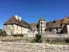
- Brasserie La Rente Rouge, Lieu-dit La Rente Rouge
- Open house at the Brasserie de la Rente Rouge : tours of the workshop, tastings, local producers, meals, concerts.
| Municipality | Chargey-lès-Gray |
|---|---|
| Postcode | 70100 |
| Latitude | 47.4871080 (N 47° 29’ 14”) |
| Longitude | 5.5750890 (E 5° 34’ 30”) |
| Altitude | From 192m to 250m |
| Surface area | 16.56 km² |
| Population | 771 inhabitants |
| Density | 46 inhabitants/km² |
| Prefecture | Vesoul (63 km, 1:03) |
| Insee code | 70132 |
| Intercommunality | CC Val de Gray |
| Department | Haute-Saône |
| Territory | Franche-Comté |
| Region | Burgundy-Franche-Comté |
| Arc-lès-Gray | 4.2 km (7 min) |
|---|---|
| Auvet-et-la-Chapelotte | 5.3 km (9 min) |
| Oyrières | 5.3 km (5 min) |
| Gray | 5.6 km (10 min) |
| Gray-la-Ville | 7.4 km (12 min) |
| Rigny | 7.8 km (13 min) |
| Écuelle | 8 km (8 min) |
| Vars | 8 km (11 min) |
| Fahy-lès-Autrey | 8.3 km (16 min) |
| Autrey-lès-Gray | 8.6 km (14 min) |
| Ancier | 8.6 km (15 min) |
| Velet | 8.7 km (14 min) |
| Nantilly | 9.1 km (14 min) |
| Battrans | 9.5 km (15 min) |
| Last name | Activity type | Rate | City |
|---|---|---|---|
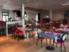
 | Entertainment | 84 € to 110 € | Besançon (44 km) |
 | Nature and the great outdoors | 49 € | Dijon (44 km) |
| Last name | Outing type | Difficulty | Duration | Departure municipality |
|---|---|---|---|---|
 | Hike | Intermediate | 2:30 | Gy (20 km) |
 | Hike | Easy | 1:50 | Gy (20 km) |
 | Hike | Intermediate | 3:10 | Gy (20 km) |
 | Hike | Easy | 2:35 | Bucey-lès-Gy (21 km) |
 | Hike | Intermediate | 1:20 | Bucey-lès-Gy (22 km) |