Liven up your holidays!

Champagnac

Tourism, holidays & weekends guide in the Cantal

Champagnac - Tourism, holidays & weekends guide in the Cantal
7.6
12

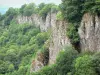
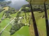
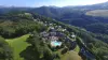
The common Champagnac is located 620 meters above sea level on the plateau of Champagnaguès, in the northwest of the Cantal (near Ydes and Saignes). It dominates the gorges of the Dordogne, it is bordered by the Correze (16 km Neuvic). It is also located 12 km from Bort-les-Organs, 22 km from Mauriac 80 km of Aurillac and 90 km from Clermont-Ferrand.

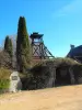
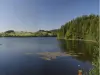
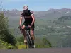
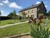
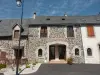
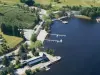
Headquarters of a major coal deposit in the last century, the old mining town has found a conversion of life in the tourism and hospitality: Mining Museum, hiking trails, fishing in the gorges of the Dordogne and dams around.

Geographical information

MunicipalityChampagnac
Postcode15350
Latitude45.3573160 (N 45° 21’ 26”)
Longitude2.3995220 (E 2° 23’ 58”)
AltitudeFrom 321m to 697m
Surface area28.01 km²
Population1062 inhabitants
Density37 inhabitants/km²
PrefectureAurillac (72 km, 1:14)
Insee code15037
IntercommunalityCC Sumène - Artense
DepartmentCantal
TerritoriesAuvergne, Massif Central
RegionAuvergne-Rhône-Alps

Nearest cities & towns

Saint-Pierre3.6 km (6 min)
Veyrières4.2 km (7 min)
Ydes4.6 km (7 min)
Sérandon8.7 km (13 min)
Madic8.7 km (15 min)
Bassignac9.1 km (12 min)
Saignes9.6 km (14 min)
Sauvat10 km (18 min)
Bort-les-Orgues11.6 km (18 min)
Antignac14.2 km (16 min)
Vebret14.3 km (17 min)
Le Monteil15.5 km (22 min)
Liginiac16.5 km (25 min)
Neuvic16.9 km (25 min)

Things to see and do

Places of interest

Monuments
Natural sites

Events and festivities

Photos

Bridge Vernéjoux
Bridge Vernéjoux
See photo
Saint Martin Church of the twelfth century
See photo
New town square, the fountain
See photo
Castle and park
Castle and park
See photo
Gorges de la Dordogne
See photo
Grouping the town shopping
See photo
Models of Mining Museum
See photo
Model of Mining Museum
See photo
Lodging of group
Lodging of group
See photo
Puy Madeleine
Puy Madeleine
See photo
Parking the Mining Museum
See photo
New town square, the monument and the church
See photo

Weather

Wednesday 24 april
Min. -2°C - Max. 10°C
Day
Night
Thursday 25 april
Min. 4°C - Max. 10°C
Day
Night
Friday 26 april
Min. 7°C - Max. 13°C
Day
Night

Visits, leisure and activities nearby

Leisure activities

Last nameActivity typeRateCity
Wakeboarding with a water-skiing school
Sports sensations20 € Lanobre (12.7 km)
Horseback riding at the Col de la Modele
Nature and the great outdoors40 € to 75 € Albepierre-Bredons (46 km)

Outings

Last nameOuting typeDifficultyDurationDeparture municipality
From Seyviolle to Tiolade
HikeIntermediate2:00Veyrières (2.9 km)
Crégut Lake
HikeIntermediate2:30Saint-Genès-Champespe (26 km)
Village of Fontanges
Village visitEasy1:00Fontanges (28 km)
Ascent of the Col de la Geneste
Cycling itineraryIntermediate40 minPicherande (33 km)
Climb of the Banne d'Ordanche
Cycling itineraryIntermediate20 minMurat-le-Quaire (39 km)

Restaurants

Bed & breakfasts

Vacation rentals

Campsites

Hotels

Your holidays
A hotel
A vacation rental
A bed & breakfast
A campsite
A leisure activity
A restaurant
A rental car
A plane ticket
By continuing to browse our site, you are agreeing to the use of cookies to improve your experience and make targeted offers.
Find out more and make settings
Your account