Cessy is a commune of Ain, in the Auvergne-Rhône-Alpes region, south of Gex which it borders.
Its 6.5 km² territory ranges from 496 to 583 m above sea level, located on a plateau at the foot of the Jura massif.
Its proximity to Gex and the Swiss border (the agglomeration of Geneva is only 15 km away to the south-east) has boosted its demography in recent decades: the locality now has 4,900 inhabitants. This is also reflected in an urbanization that now covers a third of its area. However, there are still 43% of agricultural land, 15% of meadows and 6% of forests...
Watered by torrents descending from the Jura, the locality already occupied during prehistory appeared in the 9th century when religious settlers from Saint Claude. The count and then the bishop of Geneva entrusted the parish to them and a priory was created. At the turn of the 17th century, the fiefdom of Cessy passed from the Colonier family to François de Bourgeois, then other nobles succeeded each other at the head of the small seigneury until the Revolution.
Mainly agricultural, the town developed like the Pays de Gex after the Second World War and even more markedly since the 1980s. However, a large part of its bucolic environment has been preserved. The leisure offer of Cessy thus deserves attention.
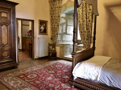
In terms of heritage, the town has two major sites. The first is the castle of Cessy, also known as the Coligny castle, named after this powerful family of the nobility of the Ancien Régime whose possessions extended over Burgundy, Franche-Comté, Bresse and Bugey. A former fortified house dating from the 15th century, the estate has been remodeled over the centuries but still has a 17th century barn. The set was acquired by the municipality in 2019 when a real estate project threatened the integrity of the site which includes a park and a pond. The castle and its exteriors must be enhanced to eventually accommodate the public and events while remaining a "green lung".
Also worth seeing is the parish church of Saint-Denis, whose foundations date back to the 11th century. The choir of the current building was then the chapel of a priory founded by monks from Saint-Claude. The convent buildings have disappeared. In the 16th century, the church, like the region, passed over to Protestantism, and Catholic worship was not reestablished until 1609. Later, the nave was burned down in 1754, and in 1853, the bell tower and facades were rebuilt. Finally, in the 1970s, the walls and the vault were stripped bare, highlighting the stone and tufa, while the floor was covered with bricks and the furniture renewed. Neo-Gothic style, the whole does not lack charm.
In terms of culture, the Vidolet space, which has two rooms, regularly hosts shows (theater, concerts). Information on programming on +33 4 50 41 56 46. In addition, the library offers activities (readings, meetings) throughout the year. Contact on +33 4 50 41 13 08.
In another register, three football pitches, a basketball court and tennis courts are available to athletes, even passing through. Inquire on +33 4 50 41 56 46.
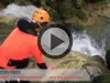
In terms of "nature" leisure, the town has 200 hectares of forest spread over three distinct sectors of the high Jura range. There is an interesting variety of vegetation. The first in the Perret sector is rich in beeches, the second in the Montchanais sector is planted with oaks, maples, Scots pines and mountain elms, and the last, in the Puthod-Abergement sector, more rugged, shelters conifers. There are marked hiking trails on each of the trails to be followed on foot in summer or on skis or even snowshoes in winter… Enough to enjoy a rich fauna (chamois, wild cats, grouse…).
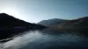
Furthermore, on the edge of the municipalities of Sauverny and Grilly, the municipality of Cessy owns a vast group of plots of marshes, meadows and forests. A recreation area of 10 hectares has been developed there. It includes a wooded part in which pedestrian paths meander and a grassy part where a fitness trail has been traced. It is completed by an artificial pond with an area of 2.7 hectares. The set is a place to walk and rest in a bucolic setting (picnic tables available). Note that fishing is authorized from the first Saturday in April to the last Sunday in November. It is imperative to have a card issued by the tourist office (info on +33 4 50 28 09 16).
It should be noted that other hiking routes are possible outside the sectors already mentioned, which notably allow you to reach the town of Gex or to approach Switzerland to the south. Without knowing it, in the latter case, you will then be walking a hundred meters above the particle accelerator tunnel which has been installed by CERN, the European Organization for Nuclear Research, whose offices and laboratories are located in the border…
Maps and information for all hikes on +33 4 50 28 09 16.
")