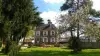
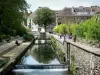
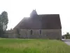
Situated in the Eure valley, the town has a small production of watercress.


Favourite
Situated in the Eure valley, the town has a small production of watercress.
| Municipality | Cailly-sur-Eure |
|---|---|
| Postcode | 27490 |
| Latitude | 49.1160750 (N 49° 6’ 58”) |
| Longitude | 1.2112880 (E 1° 12’ 41”) |
| Altitude | From 21m to 134m |
| Surface area | 3.33 km² |
| Population | 215 inhabitants |
| Density | 64 inhabitants/km² |
| Prefecture | Evreux (12.5 km, 21 min) |
| Insee code | 27124 |
| Intercommunality | CA Seine-Eure |
| Department | Eure |
| Region | Normandy |
| Clef Vallée d'Eure | 2.7 km (4 min) |
|---|---|
| Irreville | 2.8 km (4 min) |
| Heudreville-sur-Eure | 3.8 km (7 min) |
| Le Boulay-Morin | 5.1 km (6 min) |
| Dardez | 5.4 km (9 min) |
| Autheuil-Authouillet | 5.8 km (10 min) |
| Reuilly | 6.1 km (10 min) |
| Ailly | 6.1 km (8 min) |
| Saint-Vigor | 6.3 km (11 min) |
| Émalleville | 7.4 km (10 min) |
| Acquigny | 7.6 km (9 min) |
| Normanville | 8 km (10 min) |
| La Chapelle-du-Bois-des-Faulx | 8.5 km (11 min) |
| Last name | Activity type | Rate | City |
|---|---|---|---|
 | Entertainment | 40 € | Sotteville-lès-Rouen (34 km) |
| Last name | Outing type | Difficulty | Duration | Departure municipality |
|---|---|---|---|---|
 | Village visit | Easy | 1:30 | Poses (21 km) |
 | Hike | Easy | 2:00 | Poses (21 km) |
 | All-terrain bike itinerary | Easy | 55 min | Neuilly (26 km) |
 | Hike | Easy | 2:50 | Mouettes (27 km) |
 | Hike | Intermediate | 1:55 | Orival (28 km) |