Favourite
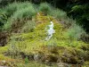
Étufs Waterfall
| Municipality | Buxerolles |
|---|---|
| Postcode | 21290 |
| Latitude | 47.8070780 (N 47° 48’ 25”) |
| Longitude | 4.9323760 (E 4° 55’ 57”) |
| Altitude | From 324m to 444m |
| Surface area | 11.97 km² |
| Population | 38 inhabitants |
| Density | 3 inhabitants/km² |
| Prefecture | Dijon (93 km, 1:09) |
| Insee code | 21123 |
| Intercommunality | CC du Pays Châtillonnais |
| Department | Côte-d'Or |
| Territory | Burgundy |
| Region | Burgundy-Franche-Comté |
| Chambain | 1.6 km (3 min) |
|---|---|
| Gurgy-le-Château | 2.8 km (4 min) |
| Colmier-le-Haut | 4.8 km (8 min) |
| Menesble | 5.2 km (11 min) |
| Colmier-le-Bas | 6 km (10 min) |
| Gurgy-la-Ville | 6.5 km (11 min) |
| Recey-sur-Ource | 7.7 km (11 min) |
| Faverolles-lès-Lucey | 9.1 km (14 min) |
| Villars-Santenoge | 9.2 km (15 min) |
| Chaugey | 9.3 km (15 min) |
| Villars-Montroyer | 9.5 km (15 min) |
| Arbot | 10 km (14 min) |
| Germaines | 10.5 km (12 min) |
| Lucey | 11.2 km (16 min) |
| Last name | Activity type | Rate | City |
|---|---|---|---|
 | Entertainment | 30 € to 40 € | Ville-sur-Arce (49 km) |
| Last name | Outing type | Difficulty | Duration | Departure municipality |
|---|---|---|---|---|
 | Hike | Easy | 4:10 | Villars-Santenoge (7 km) |
 | Hike | Easy | 3:25 | Villars-Santenoge (7 km) |
 | Cycling itinerary | Intermediate | 4:15 | Auberive (9.5 km) |
 | Cycling itinerary | Intermediate | 5:00 | Auberive (9.9 km) |
 | Cycling itinerary | Intermediate | 3:00 | Auberive (9.9 km) |