- Location of Brézins:
- Brézins is a municipality located in the department of Isere (38), at an altitude of 363 meters. It extends over 870 hectares.
- Municipality of the Canton of Saint-Etienne-de-Saint-Geoirs, it is part of the Community of Communes of Bievre-Liers (20 municipalities including the city center is La Côte-Saint-André).
- Brézins and its history:
- The village has at different times successively carried different names such as Berziacum, Brezianicum, Brizens and Berzin, before being called Brézins. Its inhabitants are called Brézinois.
- The presence of the Roman aqueduct that probably attests Brézins was founded by the Romans, masters of the world at the time, who settled along the path of Alpis Cottia enjoying a game-filled plains.
- After the invasions of the Burgundians in 443 and the Frankish Empire in 534, the taking possession by Charlemagne in 733, the various invasions that have followed have placed the region as a land of feudal and manorial system.
- The town and was the royal hunting grounds for Louis François 1st and 11th when they went on their land and Bressieux of Côte-Saint-André.
- The revolution brought a radical change. In 1790, Brézins was attached to the canton of Saint-Etienne-de-Saint-Geoirs, the first city council and the mayor was first introduced in 1791.
- The installation at the town hall was held in 1836 only after oath of advisors.
- Breziacum the Middle Ages and then in 1317 to become Brizens Berzin in 1800 and finally Brézins in the 20th century, the town was nearly halved in the mid 19th century, the inhabitants of "Brézins Lower" and "High Brézins "making division, divisions lasted until World War II.
- The town has seen many floods. Archives indicate damage from river flooding "the rival" in 1841, in 1856, in 1857, and most recently in 1988, 1992 and 2008.
- Did you know? Brézins houses a Roman aqueduct, a true relic of a past civilization.
- Brézins and its population: in 1790, 700 inhabitants in 1851, 1045 inhabitants in 1901, 1019 inhabitants in 1914, 900 inhabitants in 1946, 739 inhabitants in 1968, 671 inhabitants in 1982, 1,100 inhabitants in 2002 , 1321 inhabitants in 2010, 1759 inhabitants.
- Brézins and buildings:
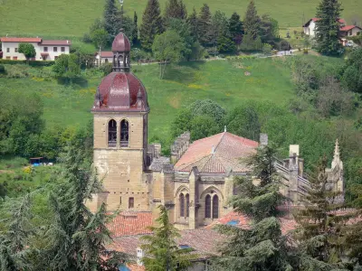
- Churches: The first records of a church dating from 1457, a mass called "matinière" there being held in a small church, chapel, without nave or spire. In 1662 a steeple was built in 1711 and consolidation work was carried out. In 1842 the church was enlarged but the relief claimed by the inhabitants in 1845 then in 1855 have never been undertaken. In May 1857, following the divisions between people, the council decided to share Brézins in two, parallel to the railway torrent "The Rival" marking the separation. The inhabitants of the "Up" having built a church through subscriptions in 1856, repairs to the church of "Low" were determined. In 1859, the cult was given in both churches. In 1904, the separation of church and state has failed to evolve and it was not until 1964 that the church is closed and the bottom than the top becomes the only seat of the parish.
- Schools: With the separation of "Low" and "High", the municipality has built a high school in 1898. It was not until 1956 and the construction of a new school in the village center down to having only one school.
- The Cemetery: The cemetery no longer in compliance with the law, the City Council created a new cemetery in 1846. Located Road La Côte-Saint-André is always the one in operation today.
- Post: In 1842, Brézins was served by mail of Saint-Etienne-de-Saint-Geoirs. On petitions, a factor is assigned to Brézins in 1896. The installation of a factor / recipient is officially recorded in 1927 in municipal premises. In 1937, the town converted the station to its present location.
- The war memorial was erected August 15, 1922 at the current location.
- The railway, in 1845, the first studies to take place a line of railway. St Rambert line - Rives was born in 1866. Following calls from elected in 1888 and 1892, a station was created in 1902 to Brézins open only to passengers. Open to goods in 1903, the line ceased in 1983 with the last freight trains. The station was demolished in 2001.
- Shield of Brézins:
- On the top of the shield communal, the crenellated crown recalls the many invasions suffered by the village and the two dolphins are there to signify membership in the former province of Dauphiné.
- At the bottom, then we find the following characteristic features: the hawk, raptor hovering mostly above fields, sunflower and corn, the symbol of agriculture practiced on the lands of the commune; blue and wavelets, evocation of Rival, streams through the village, the house typically dauphinoise which a model is displayed in a museum Dauphinois in Grenoble.