Bretagne-d'Armagnac is a commune in the Gers department, in the Occitanie region, a few kilometers northeast of Eauze.
Its territory of 12 km² belongs historically and culturally to Bas-Armagnac, also known as "land of black Armagnac", which stretches between the valleys of Auzoue, Gélise and Douze. and Midou.
The landscapes of the locality have remained rural and green: it is covered with crops (including many vineyards) and other agricultural areas (70% of its surface area), forests (18%) and meadows (6%). There are also sensitive and protected areas for their biodiversity, notably the ponds and moors of Zou-Fou-Dou, in the north of the commune.
The village which takes its name from its belonging to English Guyenne during the Hundred Years' War appeared in the 13th century in the form of a bastide: a new town whose lord was the Count of Armagnac but which only developed modestly due to the proximity of other centers such as Eauze and Montreal.
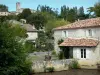
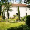
Today, however, there remain some heritage elements of interest on Bretagne-d'Armagnac (nearly 400 inhabitants). With its green and bucolic environment and the quality of its wine estates, this is something to delight lovers of green tourism, hiking and wine tasting.
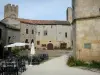
In addition to the remains of a Gallo-Roman villa (mosaics, pottery and coins have been unearthed) in the place called Ségues, a heritage discovery trail obviously begins with the heart of the small bastide: in this case its large square central square, where we can still see some covered areas (arcades). However, the village only modestly developed around it, via checkerboard streets, as was the case elsewhere.
On the southwest corner, the Saint-Jean-Baptiste parish church has been remodeled several times but its foundation is contemporary with the bastide. The nave is flanked by a quadrangular tower supported by buttresses surmounted by the more recent hexagonal bell tower. Displaying materials combining bricks, pebbles and limestone, the church is accessible via a portal with Gothic arches and smooth columns. The tympanum is decorated with a statue of the Virgin. Finally, an ancient monolithic cross once located on the square is now installed in front of the tower.
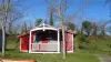
To the north of the town, on the road to the old station, an old washhouse has been preserved, a second having been built to the south, following the Second War (proof that daily life still remained difficult for some points…).
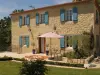
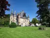
To the south of the old bastide, again, we can observe the Château de Garderon, whose bases date back to the 15th century and which came under the lordship of Aydie. The estate is still private and has retained original elements (turrets, fortified walls).
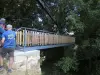
When it comes to leisure, hikers are having a blast. The town is crossed to the north by the famous GR 65, which follows the route of the Way of Saint-Jacques coming from Geneva and Puy-en-Velay (the Via Podensis) via Aubrac, Quercy then Agenais...
Furthermore, the Gers department has developed the Armagnac Greenway on the old railway line linking Condom to Riscle. Enough to delight walkers or mountain bikers over several dozen kilometers. This secure track is accessible to the north of the town, near the old train station...
Other trails and circuits dedicated to cyclists are also available, allowing you to enjoy the bucolic landscapes and hillsides planted with vines … Maps and information from the intercommunal tourist office on +33 5 62 09 85 62.
You may prefer a horse or pony ride: contact the Ecurie d’Off on +33 6 84 05 41 94.
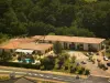
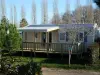
As you walk, it is easy to follow the Armagnac lakes area, a vast area of 50 hectares in the north of the territory, which includes a campsite with a leisure center (reserved for holidaymakers staying on the site). The bodies of water and their deliberately shaded environment happily mark out a walk.
For campers, information on +33 5 62 09 70 92.
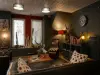
All that remains to be done, for wine lovers and enthusiasts, is at one of the estates that make the reputation of the town, for a tasting… with moderation of Côtes de Gascogne appellation wines and Armagnac eau-de-vie. Let us mention the domain of Lartigue (contact on +33 5 62 09 90 09), the domain of Ménard (contact +33 5 62 29 13 33) and that of Faron (information on +33 5 62 09 93 84).