- History:
- Originally Bourbach-le-Haut is only a hamlet, attached to the Abbey of Masevaux. The first mention of the village appears in a fake diploma manufactured in the twelfth century, attributed to Louis the Pious and bearing date of June 21, 823.
- The village population, decimated as a result of the Thirty Years War, increases with a major Austrian immigration, with name remain. Most residents were loggers, farmers and sometimes coal, as evidenced by the hill Kohlberg (from Kohle, coal and Berg, mountain) surrounding the village.
- During the Revolution, villagers revolt, and in 1792 Bourbach-le-Haut is recognized as an independent municipality.
- In the nineteenth century, the first civil registers are open, and new activities such as weaving appear.
- The village is released on 7 August 1914. In 1914 Marshal Joffre built the road from Masevaux in Thann.
- From 1940 to 1944, the inhabitants of German troops should stay in their homes. Bourbach-le-Haut will lose six men conscripted in German uniform. After the Second World War, the village is experiencing a rural exodus that reversed after 1970, stabilizing the population around 280 inhabitants.
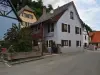
- Today the town has about 450 inhabitants: the High Bourbachois.
- Location:
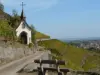
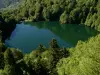
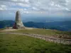
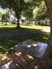
- Nestled in the mountains (650 m above sea level and up to 1200 m to Waldmatt) like an eagle's nest in the rocks, Bourbach-le-Haut is a typical mountain village which extends over 686 hectares. A visitor would feel quite enclosed by the peaks crowned with pine forests in the South if it discovered that the plain of Alsace in all its splendor extends to its feet. And on a clear day he discovered beyond the scope of this impressive chain of the Bernese Alps: Finsterahorn, Eiger, Mönch, Jungfrau, all the giants are there, cutting their dark silhouette against the light of the rising sun. The slopes of the Vosges are not as steep as those of the Alps but in this place they are no less wild. Pastures dotted with countless rocks that evolve effortlessly sheep, invite visitors to beautiful walks. How to resist the urge to climb up there? If the rise is a little difficult to reach the summit of joy will be even greater, and up there an unforgettable sight awaits. On one side appears the Thur so beautiful valley with small peaks all shaved the other stretches the Vallée de Masevaux quite different by its flourishing fir forests. Although isolated Bourbach-le-Haut seems it would be wrong to believe because appearances are often misleading. Between these two valleys connected by road Joffre the village takes a tourist ever growing importance. By Joffre road Masevaux is 5 km and 14 km Thann. In addition, the road leading to Bourbach-le-Bas puts Mulhouse at 30 km. Is it possible that you're only 70 km from Basel, 27 km from Belfort and 45 km from Colmar? What is extraordinary and makes it unique is that the center of this circus nature has created a small geographical world. The village is divided into numerous ramifications along with charming small valleys. The geographer can distinguish an entire river system in miniature in which the Bourbach tirelessly pursues its capricious race through fields and meadows, over the many rocks that dot. In the summer of course, the water level drops significantly but trout likes it a lot. This fish has the distinction of always swimming against the current, loves jumping over waterfalls. Everyone knows that the cascades are not lacking, the huge blocks of porphyry polished by the time machine are so numerous.
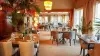
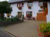
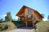
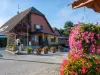
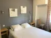
- A Bourbach-le-Haut the word hospitality is not an empty word since camper vans, accommodation, a restaurant and an inn farm, offering rest stays hikers, anglers and walkers wishing to discover a place where life is good.