Liven up your holidays!

Blénod-lès-Toul

Tourism, holidays & weekends guide in the Meurthe-et-Moselle

Blénod-lès-Toul - Tourism, holidays & weekends guide in the Meurthe-et-Moselle
8.5
4

Geographical information

MunicipalityBlénod-lès-Toul
Postcode54113
Latitude48.5986390 (N 48° 35’ 55”)
Longitude5.8322660 (E 5° 49’ 56”)
AltitudeFrom 229m to 432m
Surface area17.60 km²
Population1048 inhabitants
Density59 inhabitants/km²
PrefectureNancy (33 km, 33 min)
Insee code54080
IntercommunalityCC du Pays de Colombey et du Sud Toulois
DepartmentMeurthe-et-Moselle
TerritoryLorraine
RegionGreat East

Nearest cities & towns

Mont-le-Vignoble2.7 km (5 min)
Bulligny4.4 km (7 min)
Crézilles5 km (8 min)
Charmes-la-Côte5.4 km (11 min)
Domgermain6.4 km (12 min)
Gye7.4 km (8 min)
Vannes-le-Châtel8.4 km (10 min)
Bicqueley8.4 km (13 min)
Barisey-la-Côte8.8 km (13 min)
Rigny-Saint-Martin9.5 km (9 min)
Moutrot9.7 km (15 min)
Allamps10.2 km (12 min)
Bagneux10.7 km (14 min)
Ochey10.8 km (22 min)

Things to see and do

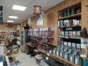
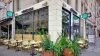
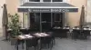
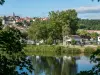
Vineyard always open to visitors who can enjoy but also find the roots of the ancestral work and visit the lodges.

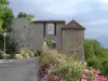
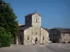
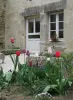
The Association for the Preservation of Architectural Heritage and Cultural Blénod-lès-Toul, since 1980, has acquired several lodges and renovated. These lodges are part of a tour offered to tourists coming to the winery. They were built in the Renaissance by the Bishop of Toul Hugues of Hazards.

Places of interest

Monuments

Photos

Toul vineyards
Toul vineyards
See photo
lodges built by Hugh of Hazards
See photo

Weather

Thursday 25 april
Min. 2°C - Max. 10°C
Day
Night
Friday 26 april
Min. 5°C - Max. 13°C
Day
Night
Saturday 27 april
Min. 7°C - Max. 16°C
Day
Night

Visits, leisure and activities nearby

Leisure activities

Last nameActivity typeRateCity
Shop selling local and regional products
Local flavoursFreeSorcy-Saint-Martin (19.2 km)
Making an egg in a glass artist's studio
Arts and CraftsFreeHeudicourt-sous-les-Côtes (38 km)

Outings

Last nameOuting typeDifficultyDurationDeparture municipality
Villey-Saint-Étienne structures
HikeEasy2:00Villey-Saint-Étienne (18.1 km)
In the footsteps of Jeanne, around Domremy
HikeIntermediate3:20Maxey-sur-Meuse (19.3 km)
Tour of Liverdun
HikeEasy2:00Liverdun (24 km)
Xaintoise Getaway
HikeEasy7:35Vaudémont (27 km)
Walk around Neufchateau
HikeEasy1:55Neufchâteau (28 km)

Restaurants

Bed & breakfasts

Vacation rentals

Campsites

Hotels

Your holidays
A hotel
A vacation rental
A bed & breakfast
A campsite
A leisure activity
A restaurant
A rental car
A plane ticket
By continuing to browse our site, you are agreeing to the use of cookies to improve your experience and make targeted offers.
Find out more and make settings
Your account