Liven up your holidays!

Bayon

Tourism, holidays & weekends guide in the Meurthe-et-Moselle

Bayon is located halfway between the towns of Nancy and Épinal.

Its origin dates back to the time of the Roman conquest, since in the past it was a Roman oppidum.

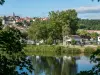
The town was built on the natural promontory of the Lebel coast. Its geographical position offered natural defenses with the Moselle on one side and the Euron on the other. Bayon has known constant occupation since the Gauls.

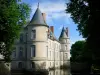
In 1172, the land of Bayon was given in appanage to Henri le Lombard, youngest of the House of Lorraine, son of Duke Ferry I of Bitche. It was he who, at the beginning of the 13th century, had a defensive castle built as well as thick walls (access to which was guarded by three gates). Through the vicissitudes of low and high averaging and the conflicts that follow one another, the town has experienced various fortunes. Thus, December 24, 1635, during the Thirty Years' War, the Duke of Longueville, seized the city on behalf of the King of France. The city was once again plundered and set on fire and the fortress ended like most fortified castles in Lorraine, dismantled in 1636 by order of Louis XIII and Richelieu. The last traces of this feudal past will disappear with the Revolution.

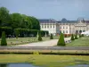
Bayon then entered the modern and industrial era with the establishment of a tile factory, a mechanical cooperage, a bolting, an agricultural cooperative, a mill and of course the Chicory plant. Unfortunately from this rich past only a few traces remain.

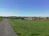
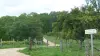
Bayon is a rural town near the Vosges. It is a great place for walks and nature discovery activities. In addition to the communal ponds of Saussaie (fishing possible), the Moselle borders the town. The bed of this river is classified as a wild Moselle regional reserve. Part of its territory is also classified as a Natura 2000 zone.

Geographical information

MunicipalityBayon
Postcode54290
Tourism label
Latitude48.4775800 (N 48° 28’ 39”)
Longitude6.3141470 (E 6° 18’ 51”)
AltitudeFrom 242m to 397m
Surface area6.05 km²
Population1548 inhabitants
Density255 inhabitants/km²
PrefectureNancy (33 km, 28 min)
Insee code54054
IntercommunalityCC Meurthe Mortagne Moselle
DepartmentMeurthe-et-Moselle
TerritoryLorraine
RegionGreat East

Nearest cities & towns

Virecourt2 km (3 min)
Roville-devant-Bayon2.5 km (4 min)
Haigneville2.9 km (5 min)
Lorey3.1 km (4 min)
Saint-Mard3.6 km (4 min)
Mangonville3.8 km (7 min)
Laneuveville-devant-Bayon4 km (5 min)
Neuviller-sur-Moselle4 km (5 min)
Froville4.3 km (6 min)
Brémoncourt4.5 km (6 min)
Villacourt4.8 km (8 min)
Bainville-aux-Miroirs6 km (8 min)
Méhoncourt6 km (6 min)
Domptail-en-l'Air6.2 km (9 min)
Saint-Germain6.2 km (10 min)

Things to see and do

Events and festivities

Weather

Thursday 25 april
Min. 2°C - Max. 9°C
Day
Night
Friday 26 april
Min. 5°C - Max. 13°C
Day
Night
Saturday 27 april
Min. 7°C - Max. 17°C
Day
Night

Visits, leisure and activities nearby

Leisure activities

Last nameActivity typeRateCity
Exhibition by a creator of stories and shows
Culture and education12 € Laveline-devant-Bruyères (47 km)

Outings

Last nameOuting typeDifficultyDurationDeparture municipality
The Charmoise
HikeEasy3:30Charmois (8.6 km)
The Tops of Vigneulles
HikeEasy1:30Vigneulles (9.5 km)
Coughing wood
HikeEasy2:00Blainville-sur-l'Eau (10.9 km)
Vines and steeples
HikeIntermediate5:00Charmes (11.3 km)
Xaintoise Getaway
HikeEasy7:35Vaudémont (19.5 km)

Restaurants

Bed & breakfasts

Vacation rentals

Campsites

Hotels

Your holidays
A hotel
A vacation rental
A bed & breakfast
A campsite
A leisure activity
A restaurant
A rental car
A plane ticket
By continuing to browse our site, you are agreeing to the use of cookies to improve your experience and make targeted offers.
Find out more and make settings
Your account