At the crossroads of three departments, the Gard, Lozère and Ardèche, Aujac is located on the D51 which connects Saint Ambrose in Villefort at the foot of Mont Lozère.


Favourite


At the crossroads of three departments, the Gard, Lozère and Ardèche, Aujac is located on the D51 which connects Saint Ambrose in Villefort at the foot of Mont Lozère.
| Municipality | Aujac |
|---|---|
| Postcode | 30450 |
| Latitude | 44.3479079 (N 44° 20’ 52”) |
| Longitude | 4.0142020 (E 4° 0’ 51”) |
| Altitude | From 256m to 940m |
| Surface area | 16.47 km² |
| Population | 184 inhabitants |
| Density | 11 inhabitants/km² |
| Prefecture | Nîmes (89 km, 1:35) |
| Insee code | 30022 |
| Intercommunality | CA Alès Agglomération |
| Department | Gard |
| Territory | Languedoc-Roussillon |
| Region | Occitanie |
| Bonnevaux | 5 km (12 min) |
|---|---|
| Malbosc | 8.5 km (14 min) |
| Bordezac | 8.8 km (14 min) |
| Sénéchas | 10.1 km (17 min) |
| Génolhac | 10.3 km (17 min) |
| Concoules | 10.9 km (18 min) |
| Ponteils-et-Brésis | 11.6 km (19 min) |
| Peyremale | 12.8 km (19 min) |
| Saint-André-Capcèze | 13.4 km (20 min) |
| Chamborigaud | 13.7 km (23 min) |
| Malons-et-Elze | 14.2 km (23 min) |
| Bessèges | 15.9 km (25 min) |
| Vialas | 17 km (27 min) |
| Villefort | 18.3 km (26 min) |
| Leisure centres |
|---|
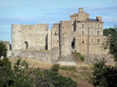
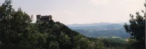
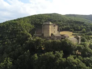
At Castle Aujac, the first weekend of August: the Malabestia. Over 50 people in civilian clothes and military, give new life to the castle of the eighteenth century. Discover the daily life in the time of the Beast of Gevaudan!


| Last name | Activity type | Rate | City |
|---|---|---|---|
 | Sports sensations | 16 € | Chassagnes (13.9 km) |
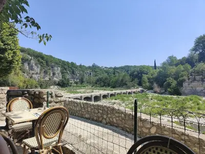
 | Sports sensations | 10 € to 42 € | Berrias-et-Casteljau (16.5 km) |
 | Sports sensations | 35 € | Casteljau (16.7 km) |
 | Entertainment | 12 € | Sanilhac (25 km) |
 | Sports sensations | 50 € to 55 € | Allègre-les-Fumades (25 km) |
| Last name | Outing type | Difficulty | Duration | Departure municipality |
|---|---|---|---|---|
 | Hike | Intermediate | 5:00 | Bonnevaux (1.9 km) |
 | Hike | Easy | 2:30 | Villefort (12 km) |
 | Hike | Intermediate | 3:00 | Robiac-Rochessadoule (12.1 km) |
 | Hike | Easy | 1:30 | Casteljau (14 km) |
 | Hike | Intermediate | 3:00 | Ventalon en Cévennes (14.2 km) |