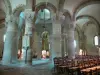
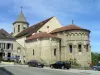
- Church
- Numerous wells

Favourite
| Municipality | Aigurande |
|---|---|
| Postcode | 36140 |
| Latitude | 46.4340110 (N 46° 26’ 2”) |
| Longitude | 1.8285970 (E 1° 49’ 43”) |
| Altitude | From 284m to 442m |
| Surface area | 27.77 km² |
| Population | 1412 inhabitants |
| Density | 50 inhabitants/km² |
| Prefecture | Châteauroux (49 km, 51 min) |
| Insee code | 36001 |
| Intercommunality | CC de la Marche Berrichonne |
| Department | Indre |
| Territory | Berry |
| Region | Centre-Loire Valley |
| Lourdoueix-Saint-Pierre | 3.3 km (5 min) |
|---|---|
| Méasnes | 4.8 km (7 min) |
| La Forêt-du-Temple | 6.7 km (10 min) |
| Crozon-sur-Vauvre | 7.9 km (12 min) |
| La Buxerette | 8.6 km (12 min) |
| Montchevrier | 9.3 km (9 min) |
| Lourdoueix-Saint-Michel | 9.5 km (13 min) |
| Nouzerolles | 9.9 km (16 min) |
| Linard-Malval | 10.4 km (12 min) |
| Nouziers | 10.6 km (12 min) |
| Mortroux | 11 km (14 min) |
| Chambon-Sainte-Croix | 11 km (9 min) |
| Moutier-Malcard | 12 km (14 min) |
| Crevant | 12.4 km (11 min) |
| Information points |
|---|
| Last name | Outing type | Difficulty | Duration | Departure municipality |
|---|---|---|---|---|
 | Hike | Easy | 3:00 | Moutier-Malcard (10.1 km) |
 | Car itinerary | Easy | 45 min | Saint-Sébastien (23 km) |
 | Car itinerary | Easy | 1:00 | Ahun (42 km) |
 | Village visit | Easy | 3:00 | Soubrebost (53 km) |
 | Hike | Easy | 2:00 | Chambon-sur-Voueize (53 km) |