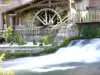
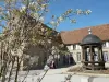
Its ancient buildings dating from the 18th century. Achy Castle is managed by the Little Brothers of the Poor.


Favourite
| Municipality | Achy |
|---|---|
| Postcode | 60690 |
| Latitude | 49.5530860 (N 49° 33’ 11”) |
| Longitude | 1.9772040 (E 1° 58’ 38”) |
| Altitude | From 91m to 187m |
| Surface area | 12.70 km² |
| Population | 414 inhabitants |
| Density | 32 inhabitants/km² |
| Prefecture | Beauvais (19.1 km, 21 min) |
| Insee code | 60004 |
| Intercommunality | CC de la Picardie Verte |
| Department | Oise |
| Territory | Picardy |
| Region | Hauts-de-France |
| Villers-sur-Bonnières | 2.5 km (6 min) |
|---|---|
| Marseille-en-Beauvaisis | 3.2 km (4 min) |
| La Neuville-sur-Oudeuil | 3.4 km (8 min) |
| Saint-Omer-en-Chaussée | 3.9 km (5 min) |
| Fontaine-Lavaganne | 5.8 km (8 min) |
| Oudeuil | 6.5 km (9 min) |
| Rothois | 7 km (8 min) |
| Milly-sur-Thérain | 7.2 km (10 min) |
| Roy-Boissy | 7.4 km (11 min) |
| Haute-Épine | 7.5 km (8 min) |
| Gaudechart | 8.1 km (10 min) |
| Grémévillers | 8.4 km (10 min) |
| Saint-Maur | 8.6 km (10 min) |
| Blicourt | 9 km (13 min) |
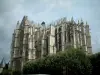
Its ancient buildings dating from the 18th century. Achy Castle is managed by the Little Brothers of the Poor.
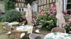
| Monuments |
|---|
| Last name | Outing type | Difficulty | Duration | Departure municipality |
|---|---|---|---|---|
 | Hike | Easy | 50 min | Gournay-en-Bray (19.9 km) |
 | Hike | Easy | 3:00 | Courcelles-sous-Moyencourt (29 km) |
| Hike | Intermediate | 4:00 | Courcelles-sous-Moyencourt (29 km) |
 | Hike | Easy | 2:00 | Paillart (29 km) |
 | Hike | Easy | 35 min | Forges-les-Eaux (32 km) |