


Favourite
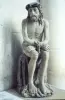
Troyes Museum of Modern Art
| Municipality | Villechétif |
|---|---|
| Postcode | 10410 |
| Latitude | 48.3155900 (N 48° 18’ 56”) |
| Longitude | 4.1473509 (E 4° 8’ 50”) |
| Surface area | 12.24 km² |
| Population | 969 inhabitants |
| Density | 79 inhabitants/km² |
| Prefecture | Troyes (7.2 km, 13 min) |
| Insee code | 10412 |
| Intercommunality | CA Troyes Champagne Métropole |
| Department | Aube |
| Territory | Champagne-Ardenne |
| Region | Great East |
| Bouranton | 2.8 km (7 min) |
|---|---|
| Saint-Parres-aux-Tertres | 3.1 km (6 min) |
| Creney-près-Troyes | 3.6 km (5 min) |
| Thennelières | 4.5 km (9 min) |
| Pont-Sainte-Marie | 4.7 km (7 min) |
| Lavau | 6.6 km (9 min) |
| Ruvigny | 6.7 km (11 min) |
| Mesnil-Sellières | 7.4 km (10 min) |
| Troyes | 7.6 km (13 min) |
| Laubressel | 8.2 km (12 min) |
| Sainte-Maure | 8.9 km (12 min) |
| Vailly | 9.5 km (10 min) |
| Rouilly-Sacey | 10.1 km (13 min) |
| Last name | Activity type | Rate | City |
|---|---|---|---|
 | Entertainment | 30 € to 40 € | Ville-sur-Arce (32 km) |
| Last name | Outing type | Difficulty | Duration | Departure municipality |
|---|---|---|---|---|
 | Hike | Easy | 50 min | Troyes (5.5 km) |
 | Hike | Easy | 2:10 | Troyes (5.7 km) |
 | Hike | Easy | 1:55 | Lusigny-sur-Barse (12.5 km) |
 | Hike | Easy | 4:00 | Géraudot (13.2 km) |
 | All-terrain bike itinerary | Easy | 3:30 | Bouilly (17.6 km) |